|
search place name
|
||
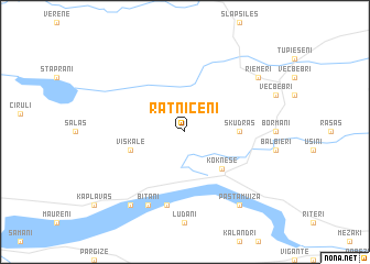
Ratnicēni (Rīgas Rajons, Latvia)Ratnicēni is a town in the Rīgas Rajons region of Latvia. An overview map of the region around Ratnicēni is displayed below.
regional and 3d topo map of Ratnicēni, Latvia ::
Nearby towns ::
Koknese (4.2km south east) //
Skudras (3.1km east) //
Viskale (3.6km south west) //
Bajāri (7.5km south) //
Bitāni (7.7km south) //
Daudziešēni (8.0km south) //
Pastamuiža (8.0km south) //
Riemeri (6.9km north east) //
[all distances 'as the bird flies' and approximate]  Places with similar names to Ratnicēni, Latvia ::
// Röddensen (DE)
// Rödinghausen (DE)
// Rüdinghausen (DE)
// Redención (CU)
// Redención (CU)
// Redención (CU)
// Rödinghausen (DE)
Disclaimer :: Information on this page comes without warranty of any kind |
||
|
Where is Ratnicēni? Elevation and coordinates ::
Latitude (lat): 56°41'0"N Longitude (lon): 25°24'0"E
Elevation (approx.): 94m (map arrows pan, magnifying glasses zoom) |
||
|
Visiting Ratnicēni? Hotel/Accommodation ::
Book a hotel in Ratnicēni Travel Guide ::
Buy a travel guide for Latvia rental cars ::
car rental offers GPS waypoint ::
download a GPX waypoint (PoI) of Ratnicēni for your GPS receiver
|
||