|
search place name
|
||
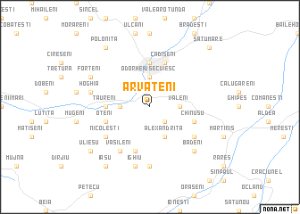
Arvăţeni (Covurlui, Romania)Arvăţeni is a town in the Covurlui region of Romania. An overview map of the region around Arvăţeni is displayed below.
regional and 3d topo map of Arvăţeni, Romania ::
Arvăţeni airports ::
The nearest airport is TGM - Tirgu Mures Vidrasau, located 71.9 km west of Arvăţeni.
Other airports nearby include SBZ - Sibiu (107.8 km south west), BCM - Bacau (127.1 km east), CLJ - Cluj-napoca Cluj Napoca (136.6 km north west), SCV - Suceava Stefan Cel Mare (177.1 km north east), Nearby towns ::
Teleac (2.3km south east) //
Odorheiu Secuiesc (3.7km north) //
Văleni (2.6km east) //
Feliceni (2.6km west) //
Alexandriţa (3.9km south) //
Beclean (5.6km north) //
Tăureni (3.8km west) //
Cădişeni (5.7km north) //
Oţeni (4.3km south west) //
Chinuşu (4.3km south east) //
Obrăneşti (5.7km south) //
Vasileni (6.1km south west) //
Locodeni (5.3km south east) //
Nicoleşti (5.3km south west) //
Daia (7.4km south) //
Hoghia (5.4km west) //
Ighiu (7.5km south) //
Bădeni (6.8km south east) //
Forţeni (6.3km north west) //
Poloniţa (8.3km north west) //
Iaşu (8.4km south west) //
Ulieşu (7.6km south west) //
Satu Mare (9.0km north east) //
[all distances 'as the bird flies' and approximate]  Places with similar names to Arvăţeni, Romania ::
// Arvaten (UZ)
Disclaimer :: Information on this page comes without warranty of any kind |
||
|
Where is Arvăţeni? Elevation and coordinates ::
Latitude (lat): 46°16'0"N Longitude (lon): 25°18'0"E
Elevation (approx.): 530m (map arrows pan, magnifying glasses zoom) |
||
|
Visiting Arvăţeni? Hotel/Accommodation ::
Book a hotel in Arvăţeni Travel Guide ::
Buy a travel guide for Romania rental cars ::
car rental offers GPS waypoint ::
download a GPX waypoint (PoI) of Arvăţeni for your GPS receiver
|
||