|
search place name
|
||
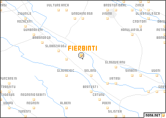
Fierbinţi (Covurlui, Romania)Fierbinţi is a town in the Covurlui region of Romania. An overview map of the region around Fierbinţi is displayed below.
regional and 3d topo map of Fierbinţi, Romania ::
Fierbinţi airports ::
The nearest airport is BBU - Bucharest Aurel Vlaicu, located 65.1 km east of Fierbinţi.
Other airports nearby include OTP - Bucharest Henri Coanda (65.6 km east), CRA - Craiova (112.9 km west), GOZ - Gorna Orechovica Gorna Oryahovitsa (153.8 km south), SBZ - Sibiu (170.9 km north west), Nearby towns ::
Ştefan cel Mare (2.6km west) //
Şelaru (3.9km south) //
Glavacioc (4.6km south west) //
Slobozia de Jos (4.4km north west) //
Negrişoara (4.4km north west) //
Slobozia (4.4km north west) //
Brăteşti (7.5km south) //
Glogoveanu (5.6km east) //
Banov (6.8km south east) //
Tăvîrlău (6.8km south east) //
Vătaşi (7.7km south east) //
[all distances 'as the bird flies' and approximate]  Places with similar names to Fierbinţi, Romania ::
// Feierabend (DE)
// Fray Benito (CU)
// Varbandeh (IR)
// Ghar Bānda (PK)
// Farabandi (ML)
// Farba Nʼ Daw (GM)
// Fahrbinde (DE)
// Ghowr Band (AF)
Disclaimer :: Information on this page comes without warranty of any kind |
||
|
Where is Fierbinţi? Elevation and coordinates ::
Latitude (lat): 44°30'0"N Longitude (lon): 25°17'0"E
Elevation (approx.): 146m (map arrows pan, magnifying glasses zoom) |
||
|
Visiting Fierbinţi? Hotel/Accommodation ::
Book a hotel in Fierbinţi Travel Guide ::
Buy a travel guide for Romania rental cars ::
car rental offers GPS waypoint ::
download a GPX waypoint (PoI) of Fierbinţi for your GPS receiver
|
||