|
search place name
|
||
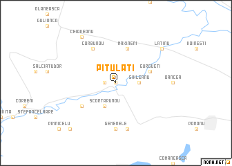
Pitulaţi (Covurlui, Romania)Pitulaţi is a town in the Covurlui region of Romania. An overview map of the region around Pitulaţi is displayed below.
regional and 3d topo map of Pitulaţi, Romania ::
Pitulaţi airports ::
The nearest airport is TCE - Tulcea Cataloi, located 92.0 km east of Pitulaţi.
Other airports nearby include CND - Constanta Mihail Kogalniceanu (129.6 km south east), BCM - Bacau (141.3 km north), OTP - Bucharest Henri Coanda (147.5 km south west), BBU - Bucharest Aurel Vlaicu (152.2 km south west), Nearby towns ::
Nicolae Bălcescu (0.0km north) //
Pitulaţii Noi (1.3km west) //
Sihleanu (2.6km east) //
Scorţaru Nou (3.9km south) //
Măxineni (5.7km north) //
Gurgueţi (4.3km north east) //
Deşiraţi (5.4km south west) //
Corbu Nou (6.1km north west) //
Gemenele (7.4km south) //
Găvani (7.5km south) //
Latinu (7.6km north east) //
Chioveanu (8.4km north west) //
Avîntu (9.1km south west) //
[all distances 'as the bird flies' and approximate]  Places with similar names to Pitulaţi, Romania ::
// Pau de Leite (BR)
// Pé do Alto (BR)
// Putletto (MM)
// Podlodów (PL)
// Petlite (BG)
// Pétélidé (BF)
// Patillita (CO)
// Pie de Alto (CO)
// Pitalito (CO)
// Pitalito (CO)
Disclaimer :: Information on this page comes without warranty of any kind |
||
|
Where is Pitulaţi? Elevation and coordinates ::
Latitude (lat): 45°21'0"N Longitude (lon): 27°37'0"E
Elevation (approx.): 14m (map arrows pan, magnifying glasses zoom) |
||
|
Visiting Pitulaţi? Hotel/Accommodation ::
Book a hotel in Pitulaţi Travel Guide ::
Buy a travel guide for Romania rental cars ::
car rental offers GPS waypoint ::
download a GPX waypoint (PoI) of Pitulaţi for your GPS receiver
|
||