|
search place name
|
||
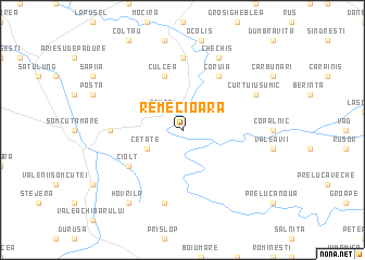
Remecioara (Covurlui, Romania)Remecioara is a town in the Covurlui region of Romania. An overview map of the region around Remecioara is displayed below.
regional and 3d topo map of Remecioara, Romania ::
Remecioara airports ::
The nearest airport is BAY - Baia Mare Tautii Magheraus, located 17.4 km north west of Remecioara.
Other airports nearby include SUJ - Satu Mare (55.2 km west), CLJ - Cluj-napoca Cluj Napoca (81.8 km south), TGM - Tirgu Mures Vidrasau (133.2 km south east), OMR - Oradea (137.3 km south west), Nearby towns ::
Între Rîuri (2.2km north east) //
Coaş (2.2km north east) //
Remeţi (2.2km north west) //
Remetea Chioarului (2.2km north west) //
Cetate (3.1km south west) //
Berchezoaia (3.1km south west) //
Culcea (5.7km north) //
Coruia (6.1km north east) //
Ciolt (5.3km south west) //
Săcălăşeni (7.4km north) //
Berchez (5.0km west) //
Codru Butesii (7.5km south) //
Buteasa (7.5km south) //
Curtuiuşu Mic (6.2km north east) //
Chechiş (7.8km north) //
Hovrila (8.3km south west) //
[all distances 'as the bird flies' and approximate]  Places with similar names to Remecioara, Romania ::
// Rumah Sare (MY)
// Rumah Serai (MY)
// Rumah Sirai (MY)
// Rumah Surau (MY)
// Remesar (ES)
// Ramseur (US)
// Ramisar (IN)
// Ramsar (IN)
// Rāmsar (IN)
// Ramsara (IN)
Disclaimer :: Information on this page comes without warranty of any kind |
||
|
Where is Remecioara? Elevation and coordinates ::
Latitude (lat): 47°31'0"N Longitude (lon): 23°34'0"E
Elevation (approx.): 248m (map arrows pan, magnifying glasses zoom) |
||
|
Visiting Remecioara? Hotel/Accommodation ::
Book a hotel in Remecioara Travel Guide ::
Buy a travel guide for Romania rental cars ::
car rental offers GPS waypoint ::
download a GPX waypoint (PoI) of Remecioara for your GPS receiver
|
||