|
search place name
|
||
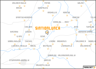
Sîntionlunca (Covurlui, Romania)Sîntionlunca is a town in the Covurlui region of Romania. An overview map of the region around Sîntionlunca is displayed below.
regional and 3d topo map of Sîntionlunca, Romania ::
Sîntionlunca airports ::
The nearest airport is BCM - Bacau, located 112.4 km north east of Sîntionlunca.
Other airports nearby include TGM - Tirgu Mures Vidrasau (133.6 km north west), SBZ - Sibiu (138.1 km west), OTP - Bucharest Henri Coanda (139.5 km south), BBU - Bucharest Aurel Vlaicu (147.1 km south), Nearby towns ::
Ghioldum (1.9km north) //
Perşunari (2.3km north east) //
Cheşnoiu (2.3km north east) //
Ozun (2.3km south west) //
Lunca Ozunului (2.3km south west) //
Lisnău (3.9km south) //
Comolău (4.5km north east) //
Bicfălău (5.6km south) //
Măgheruş (5.4km south east) //
Coşeni (5.2km west) //
Angheluş (7.5km north) //
Chilieni (5.5km west) //
Băcel (6.8km south west) //
Reci (6.4km north east) //
Chichiş (6.4km south west) //
Lisnău Vale (7.6km south east) //
Moacşa (9.0km north east) //
[all distances 'as the bird flies' and approximate]  Places with similar names to Sîntionlunca, Romania :: Disclaimer :: Information on this page comes without warranty of any kind |
||
|
Where is Sîntionlunca? Elevation and coordinates ::
Latitude (lat): 45°49'0"N Longitude (lon): 25°52'0"E
Elevation (approx.): 523m (map arrows pan, magnifying glasses zoom) |
||
|
Visiting Sîntionlunca? Hotel/Accommodation ::
Book a hotel in Sîntionlunca Travel Guide ::
Buy a travel guide for Romania rental cars ::
car rental offers GPS waypoint ::
download a GPX waypoint (PoI) of Sîntionlunca for your GPS receiver
|
||