|
search place name
|
||
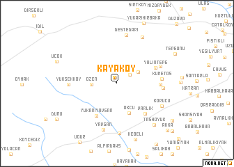
Kayaköy (Turkey)Kayaköy is a town in Turkey. An overview map of the region around Kayaköy is displayed below.
regional and 3d topo map of Kayaköy, Turkey ::
Kayaköy airports ::
The nearest airport is BAL - Batman, located 107.3 km north west of Kayaköy.
Other airports nearby include DIY - Diyabakir Diyarbakir (173.7 km north west), VAN - Van (177.2 km north east), DEZ - Deire Zor Deir Zzor (274.5 km south west), Nearby towns ::
Yörük (2.2km north east) //
Akdağ (3.3km north east) //
Özen (3.3km west) //
Okçu (4.9km south) //
Yukarıyavşan (5.8km south west) //
Varlık (6.1km south east) //
Yalıntepe (5.6km north east) //
Girahin (5.6km east) //
Kümetaş (5.8km east) //
Örencik (6.0km east) //
Dicle (6.2km north east) //
Yavşan (7.6km south) //
Yüksekköy (6.2km west) //
Deştedari (7.8km north) //
Yağmurca (8.0km south) //
Korucu (6.8km south east) //
Çağıl (8.1km north east) //
Taşhöyük (8.2km south east) //
Erdem (9.3km south east) //
‘Akkā (9.9km south east) //
Ḩājjī Maţar (10.4km south east) //
[all distances 'as the bird flies' and approximate]  Places with similar names to Kayaköy, Turkey ::
Disclaimer :: Information on this page comes without warranty of any kind |
||
|
Where is Kayaköy? Elevation and coordinates ::
Latitude (lat): 37°16'6"N Longitude (lon): 42°0'12"E
Elevation (approx.): 675m (map arrows pan, magnifying glasses zoom) |
||
|
Visiting Kayaköy? Hotel/Accommodation ::
Book a hotel in Kayaköy Travel Guide ::
Buy a travel guide for Turkey rental cars ::
car rental offers GPS waypoint ::
download a GPX waypoint (PoI) of Kayaköy for your GPS receiver
|
||