|
search place name
|
||
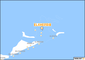
El Kheraïb (Sfax, Tunisia)El Kheraïb is a town in the Sfax region of Tunisia. An overview map of the region around El Kheraïb is displayed below.
regional and 3d topo map of El Kheraïb, Tunisia ::
El Kheraïb airports ::
The nearest airport is SFA - Sfax Thyna, located 52.1 km west of El Kheraïb.
Other airports nearby include DJE - Djerba Zarzis (109.5 km south west), MIR - Monastir Habib Bourguiba Intl (117.8 km north), GAE - Gabes (145.7 km south west), LMP - Lampedusa (147.6 km north east), Nearby towns ::
Jawābir (1.4km south) //
Ech-Chergui (2.6km south) //
Sidi el Moujahed (2.6km west) //
El Ataya (5.3km south east) //
El Abassia (6.4km south) //
Mouamla (8.1km south west) //
Kellabine (8.5km south west) //
Er-Remla (9.3km south west) //
Ouled Bou Ali (10.0km south west) //
[all distances 'as the bird flies' and approximate]  Places with similar names to El Kheraïb, Tunisia ::
// El Kherba (MA)
// El Kherba (MA)
// El Kherba (MA)
// El Kharrouba (TN)
// El Kheriba (TN)
// El Kherbé (LB)
// El Kharroûb (DZ)
// El Kharrouba (DZ)
// El Kharrouba (DZ)
// El Kherba (DZ)
Disclaimer :: Information on this page comes without warranty of any kind |
||
|
Where is El Kheraïb? Elevation and coordinates ::
Latitude (lat): 34°46'43"N Longitude (lon): 11°15'18"E
Elevation (approx.): 1m (map arrows pan, magnifying glasses zoom) |
||
|
Visiting El Kheraïb? Hotel/Accommodation ::
Book a hotel in El Kheraïb Travel Guide ::
Buy a travel guide for Tunisia rental cars ::
car rental offers GPS waypoint ::
download a GPX waypoint (PoI) of El Kheraïb for your GPS receiver
|
||