|
search place name
|
||
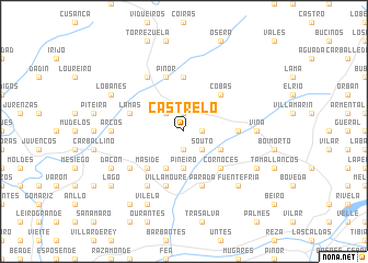
Castrelo (Galicia, Spain)Castrelo is a town in the Galicia region of Spain. An overview map of the region around Castrelo is displayed below.
regional and 3d topo map of Castrelo, Spain ::
Castrelo airports ::
The nearest airport is VGO - Vigo, located 58.3 km south west of Castrelo.
Other airports nearby include SCQ - Santiago (60.9 km north west), LCG - La Coruna A Coruna (100.0 km north), BGC - Braganca (124.3 km south east), VRL - Vila Real (132.4 km south), Nearby towns ::
Pereda (1.4km east) //
Cea (1.9km north) //
Louredo (1.9km south) //
Souto (2.3km south east) //
Fondo de Cea (2.3km north west) //
Longos (2.3km north west) //
Piñeiro (3.7km south) //
Mandrás (3.3km south east) //
Garabanes (4.0km south) //
Cobas (4.6km north east) //
Amoeiro (4.6km south east) //
Cornoces (4.6km south east) //
Maside (4.6km south west) //
La Canda (5.6km north) //
Villaseco (4.1km east) //
Parada (5.7km south) //
Piñor (5.7km north) //
Barrán (5.7km north) //
Lamas (4.5km north west) //
Armeses (5.7km south) //
Villamoure (5.7km south) //
Amarante (5.5km south west) //
Loeda (6.2km north west) //
Rañestres (6.2km south west) //
Viña (5.5km east) //
Sobreira (5.5km east) //
Arcos (5.5km west) //
Abruciños (6.9km south east) //
Fuentefría (6.9km south east) //
[all distances 'as the bird flies' and approximate]  Places with similar names to Castrelo, Spain ::
Disclaimer :: Information on this page comes without warranty of any kind |
||
|
Where is Castrelo? Elevation and coordinates ::
Latitude (lat): 42°27'0"N Longitude (lon): 7°59'0"W
Elevation (approx.): 438m (map arrows pan, magnifying glasses zoom) |
||
|
Visiting Castrelo? Hotel/Accommodation ::
Book a hotel in Castrelo Travel Guide ::
Buy a travel guide for Spain rental cars ::
car rental offers GPS waypoint ::
download a GPX waypoint (PoI) of Castrelo for your GPS receiver
|
||