|
search place name
|
||
Cela de Núñez (Comunidad Valenciana, Spain)Cela de Núñez is a town in the Comunidad Valenciana region of Spain. An overview map of the region around Cela de Núñez is displayed below.
regional and 3d topo map of Cela de Núñez, Spain ::

Cela de Núñez airports ::
The nearest airport is ALC - Alicante, located 56.7 km south of Cela de Núñez.
Other airports nearby include VLC - Valencia (78.5 km north), MJV - Murcia San Javier (116.7 km south), IBZ - Ibiza (157.2 km east), LEI - Almeria (274.6 km south west), Nearby towns ::
Benamer (1.4km east) //
Muro del Alcoy (1.9km south) //
Turballos (1.9km north) //
Alquería de Aznar (2.3km south east) //
Alcudia (3.7km south) //
Cocentaina (3.7km south) //
Alcocer de Planes (3.4km north east) //
Estación del Norte (4.0km south) //
Gayanes (4.7km north east) //
Benimarfull (4.3km east) //
Carrícola (6.3km north west) //
Beniarrés (5.7km north east) //
Otos (7.4km north) //
Cotes Bajo (7.6km south) //
Gormach (7.6km south) //
Masías de Moltó (7.6km south) //
Beniatjar (7.6km north) //
Benillup (6.9km south east) //
Bélgida (8.0km north) //
Adzaneta de Albaida (8.0km north west) //
Palomar (9.4km north west) //
[all distances 'as the bird flies' and approximate] 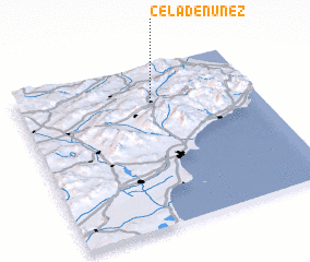 Places with similar names to Cela de Núñez, Spain :: Disclaimer :: Information on this page comes without warranty of any kind |
||
|
Where is Cela de Núñez? Elevation and coordinates ::
Latitude (lat): 38°47'0"N Longitude (lon): 0°26'0"W
Elevation (approx.): 389m (map arrows pan, magnifying glasses zoom) |
||
|
Visiting Cela de Núñez? Hotel/Accommodation ::
Book a hotel in Cela de Núñez Travel Guide ::
Buy a travel guide for Spain rental cars ::
car rental offers GPS waypoint ::
download a GPX waypoint (PoI) of Cela de Núñez for your GPS receiver
|
||