|
search place name
|
||
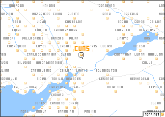
Cuns (Galicia, Spain)Cuns is a town in the Galicia region of Spain. An overview map of the region around Cuns is displayed below.
regional and 3d topo map of Cuns, Spain ::
Cuns airports ::
The nearest airport is SCQ - Santiago, located 37.3 km east of Cuns.
Other airports nearby include LCG - La Coruna A Coruna (64.1 km north east), VGO - Vigo (71.4 km south), OPO - Porto (178.6 km south), VRL - Vila Real (199.1 km south east), Nearby towns ::
Fornos (2.3km north west) //
Puente de Don Alonso (2.3km south west) //
Cando (2.3km south west) //
Filgueiro (2.3km south west) //
Romaris (2.3km north east) //
Jallas de Abajo (3.7km north) //
Outes (2.7km west) //
Gallardo (2.7km west) //
Liñayo (3.7km south) //
Roo de Abajo (3.7km south) //
Vilar (3.9km north) //
Outeiros (3.9km north) //
Orro (3.9km south) //
Agrelo (3.9km south) //
Buiste (3.3km north west) //
Casais (3.3km north west) //
Tarás (3.3km south west) //
Lourido (4.6km north west) //
Ceilán (4.6km south west) //
Vilar (5.6km north) //
Sierra de Outes (4.1km west) //
Entines (4.1km west) //
Boel (4.1km west) //
Albariza (5.6km south) //
Béjeres (5.7km south) //
Sampayo (5.7km south) //
Lueiro (4.5km north east) //
Seara (4.5km north west) //
Entines (4.5km north west) //
[all distances 'as the bird flies' and approximate]  Places with similar names to Cuns, Spain ::
Disclaimer :: Information on this page comes without warranty of any kind |
||
|
Where is Cuns? Elevation and coordinates ::
Latitude (lat): 42°51'0"N Longitude (lon): 8°52'0"W
Elevation (approx.): 241m (map arrows pan, magnifying glasses zoom) |
||
|
Visiting Cuns? Hotel/Accommodation ::
Book a hotel in Cuns Travel Guide ::
Buy a travel guide for Spain rental cars ::
car rental offers GPS waypoint ::
download a GPX waypoint (PoI) of Cuns for your GPS receiver
|
||