|
search place name
|
||
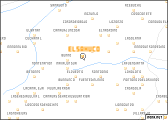
El Sahuco (Castilla-La Mancha, Spain)El Sahuco is a town in the Castilla-La Mancha region of Spain. An overview map of the region around El Sahuco is displayed below.
regional and 3d topo map of El Sahuco, Spain ::
El Sahuco airports ::
The nearest airport is ALC - Alicante, located 145.6 km east of El Sahuco.
Other airports nearby include MJV - Murcia San Javier (155.9 km south east), VLC - Valencia (166.6 km north east), LEI - Almeria (208.9 km south), GRX - Granada Armilla (219.9 km south west), Nearby towns ::
El Colmenar (2.4km north east) //
Berro (2.9km west) //
El Puerto (4.0km south) //
Navalengua (3.4km south west) //
Santa Ana (4.7km south east) //
Fuente del Pino (5.7km south) //
El Roble (4.7km north east) //
Casica del Madroño (6.3km north east) //
Burrueco (6.3km south west) //
Cañada Juncosa (6.3km north west) //
Casas de Abajo (7.6km north) //
El Madroño (7.1km north east) //
La Rambla (6.9km north east) //
El Molinar (8.0km south east) //
Fuenlabrada (8.6km south west) //
La Zarza (9.4km north east) //
[all distances 'as the bird flies' and approximate] 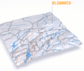 Places with similar names to El Sahuco, Spain ::
// El Sahuco (ES)
Disclaimer :: Information on this page comes without warranty of any kind |
||
|
Where is El Sahuco? Elevation and coordinates ::
Latitude (lat): 38°43'0"N Longitude (lon): 2°8'0"W
Elevation (approx.): 1190m (map arrows pan, magnifying glasses zoom) |
||
|
Visiting El Sahuco? Hotel/Accommodation ::
Book a hotel in El Sahuco Travel Guide ::
Buy a travel guide for Spain rental cars ::
car rental offers GPS waypoint ::
download a GPX waypoint (PoI) of El Sahuco for your GPS receiver
|
||