|
search place name
|
||
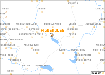
Figueroles (Comunidad Valenciana, Spain)Figueroles is a town in the Comunidad Valenciana region of Spain. An overview map of the region around Figueroles is displayed below.
regional and 3d topo map of Figueroles, Spain ::
Figueroles airports ::
The nearest airport is VLC - Valencia, located 72.8 km south of Figueroles.
Other airports nearby include REU - Reus (164.7 km north east), ZAZ - Zaragoza Ab (185.1 km north), IBZ - Ibiza (195.4 km south east), ALC - Alicante (205.6 km south), Nearby towns ::
Masía de la Parra (3.7km north) //
Masía de Guardamar de Dalt (2.8km west) //
Lucena del Cid (4.6km north west) //
Alcora (6.2km south east) //
Costur (5.7km east) //
Masía de Andreu de Dalt (5.7km west) //
Masdavall (6.0km east) //
Araya (7.0km south west) //
Useras (6.8km north east) //
Masía del Moro (6.8km south west) //
[all distances 'as the bird flies' and approximate] 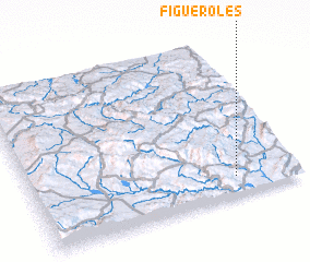 Places with similar names to Figueroles, Spain ::
// Figueruelas (ES)
// Fauguerolles (FR)
// Feugarolles (FR)
// Feuguerolles (FR)
// Fougueyrolles (FR)
// Fouquerolles (FR)
// Væggerløse (DK)
// Feuquerolles (FR)
// Figueurolles (FR)
// Fougayroles (FR)
Disclaimer :: Information on this page comes without warranty of any kind |
||
|
Where is Figueroles? Elevation and coordinates ::
Latitude (lat): 40°7'0"N Longitude (lon): 0°14'0"W
Elevation (approx.): 360m (map arrows pan, magnifying glasses zoom) |
||
|
Visiting Figueroles? Hotel/Accommodation ::
Book a hotel in Figueroles Travel Guide ::
Buy a travel guide for Spain rental cars ::
car rental offers GPS waypoint ::
download a GPX waypoint (PoI) of Figueroles for your GPS receiver
|
||