|
search place name
|
||
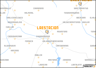
La Estación (Castilla y León, Spain)La Estación is a town in the Castilla y León region of Spain. An overview map of the region around La Estación is displayed below.
regional and 3d topo map of La Estación, Spain ::
La Estación airports ::
The nearest airport is SLM - Salamanca, located 93.4 km north east of La Estación.
Other airports nearby include VRL - Vila Real (124.9 km north west), BGC - Braganca (138.8 km north), VLL - Valladolid (184.8 km north east), BJZ - Badajoz Talavera La Real (193.3 km south), Nearby towns ::
Huertas de San Giraldo (1.4km east) //
Alameda Vieja (1.9km south) //
Arrabal de San Francisco (1.9km south) //
Arrabal del Puente (2.3km south west) //
Ciudad-Rodrigo (2.3km south west) //
Huertas de Pedrotello (3.7km south) //
Valhondo y Brocheros (4.0km south) //
Pedrotoro (4.2km east) //
Cantarranas (7.0km south east) //
Fonseca (6.7km south west) //
Malperal (9.3km north west) //
[all distances 'as the bird flies' and approximate]  Places with similar names to La Estación, Spain ::
// La Estación (ES)
// La Estación (ES)
// La Estación (ES)
// La Estación (ES)
// La Estación (ES)
// La Estación (ES)
// La Estación (ES)
// La Estación (ES)
// La Estación (ES)
// La Estación (ES)
Disclaimer :: Information on this page comes without warranty of any kind |
||
|
Where is La Estación? Elevation and coordinates ::
Latitude (lat): 40°37'0"N Longitude (lon): 6°31'0"W
Elevation (approx.): 665m (map arrows pan, magnifying glasses zoom) |
||
|
Visiting La Estación? Hotel/Accommodation ::
Book a hotel in La Estación Travel Guide ::
Buy a travel guide for Spain rental cars ::
car rental offers GPS waypoint ::
download a GPX waypoint (PoI) of La Estación for your GPS receiver
|
||