|
search place name
|
||
Miraflores (Andalucía, Spain)Miraflores is a town in the Andalucía region of Spain. An overview map of the region around Miraflores is displayed below.
regional and 3d topo map of Miraflores, Spain ::

Miraflores airports ::
The nearest airport is XRY - Jerez, located 24.4 km east of Miraflores.
Other airports nearby include OZP - Sevilla Moron Ab (80.5 km north east), SVQ - Sevilla (85.5 km north east), GIB - Gibraltar (109.3 km south east), TNG - Tanger Ibn Batouta (117.8 km south), Nearby towns ::
Pastrana (3.5km north east) //
Las Brevas (3.5km south west) //
El Botánico (4.0km north) //
Alíjar (4.5km east) //
Monte Olivete (5.6km north) //
Sanlúcar de Barrameda (5.8km north) //
La Jara (5.8km north west) //
Bonanza (7.4km north) //
Hidalgo (5.9km west) //
Pastrana (5.9km west) //
Santo Domingo (5.9km west) //
Manchuelas (6.2km west) //
Caserío Majadales (6.2km west) //
Costa de Sanlúcar (6.2km west) //
Cabeza Gorda (7.1km north east) //
[all distances 'as the bird flies' and approximate] 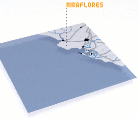 Places with similar names to Miraflores, Spain ::
// Miraflores (PA)
// Miraflores (PA)
// Miraflores (PA)
// Miraflores (PA)
// Miraflores (PA)
// Miraflores (PA)
// Miraflores (CU)
// Miraflores (CU)
// Miraflores (CU)
// Miraflores (CL)
Disclaimer :: Information on this page comes without warranty of any kind |
||
|
Where is Miraflores? Elevation and coordinates ::
Latitude (lat): 36°44'0"N Longitude (lon): 6°20'0"W
Elevation (approx.): 41m (map arrows pan, magnifying glasses zoom) |
||
|
Visiting Miraflores? Hotel/Accommodation ::
Book a hotel in Miraflores Travel Guide ::
Buy a travel guide for Spain rental cars ::
car rental offers GPS waypoint ::
download a GPX waypoint (PoI) of Miraflores for your GPS receiver
|
||