|
search place name
|
||
San Cristóbal de la Polantera (Castilla y León, Spain)San Cristóbal de la Polantera is a town in the Castilla y León region of Spain. An overview map of the region around San Cristóbal de la Polantera is displayed below.
regional and 3d topo map of San Cristóbal de la Polantera, Spain ::

San Cristóbal de la Polantera airports ::
The nearest airport is BGC - Braganca, located 88.7 km south west of San Cristóbal de la Polantera.
Other airports nearby include VLL - Valladolid (114.8 km south east), OVD - Aviles Asturias (131.6 km north), SLM - Salamanca (162.4 km south), VRL - Vila Real (195.0 km south west), Nearby towns ::
Matilla de la Vega (1.9km south) //
San Román el Antiguo (1.4km east) //
Villagarcía de la Vega (1.4km west) //
Oteruelo de la Vega (2.3km south east) //
Villamediana de la Vega (2.7km east) //
Santibáñez de la Isla (3.3km south west) //
Veguellina de Fondo (3.3km south east) //
Vecilla de la Vega (4.0km south) //
Posadilla de la Vega (3.3km north west) //
Seisón de la Vega (3.3km north east) //
Villoría de Órbigo (4.0km north) //
Santa María de la Isla (4.6km south west) //
Valdesandinas (4.6km south east) //
San Pelayo (4.6km north east) //
Huerga de Garaballes (5.6km south) //
Villarnera (4.1km west) //
Villazala (4.5km south east) //
Santa Marinica (4.5km south east) //
Garaballes (5.7km south) //
Alcaidón (5.7km south) //
Soto de la Vega (5.7km south) //
San Feliz de la Vega (4.5km north west) //
Toral de Fondo (5.5km south west) //
Palacios de la Valduerna (6.2km south west) //
Estébanez de la Calzada (6.2km north west) //
Castrillo de San Pelayo (6.2km north east) //
Santa Colomba de la Vega (7.4km south) //
Toralino (5.5km west) //
Huerga de Frailes (5.5km east) //
[all distances 'as the bird flies' and approximate] 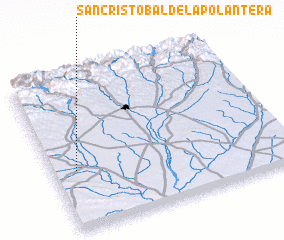 Places with similar names to San Cristóbal de la Polantera, Spain :: Disclaimer :: Information on this page comes without warranty of any kind |
||
|
Where is San Cristóbal de la Polantera? Elevation and coordinates ::
Latitude (lat): 42°23'0"N Longitude (lon): 5°54'0"W
Elevation (approx.): 792m (map arrows pan, magnifying glasses zoom) |
||
|
Visiting San Cristóbal de la Polantera? Hotel/Accommodation ::
Book a hotel in San Cristóbal de la Polantera Travel Guide ::
Buy a travel guide for Spain rental cars ::
car rental offers GPS waypoint ::
download a GPX waypoint (PoI) of San Cristóbal de la Polantera for your GPS receiver
|
||