|
search place name
|
||
Dal'novidovo (Orlovskaya Oblast', Russia)Dal'novidovo is a town in the Orlovskaya Oblast' region of Russia. An overview map of the region around Dal'novidovo is displayed below.
regional and 3d topo map of Dal'novidovo, Russia ::
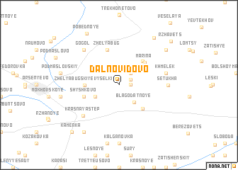
Nearby towns ::
Verkhniy Panikovets (1.1km east) //
Sergeyevka (1.4km north east) //
Nizhniy Panikovets (2.2km north east) //
Blagodatnoye (3.1km south east) //
Kar'yer (2.9km south west) //
Kolbayevka (4.3km north east) //
Arkhangel'skoye (4.3km south east) //
Zhelyabugskiye Vyselki (3.2km west) //
Mar'ina (4.3km north east) //
Zhelyabug (5.7km north) //
Shyshkovo (3.8km south west) //
(( Krasnaya Step' )) (5.9km south west) //
Khmelëk (4.8km north east) //
Setukha (4.7km east) //
Gogol' (6.5km north west) //
Kochety (8.1km north east) //
Kazinka (7.1km north east) //
Golovinovka (8.1km south west) //
Pobednoye (8.6km north) //
Kamenka (8.7km south west) //
Rzhavets (8.5km north east) //
[all distances 'as the bird flies' and approximate]  Places with similar names to Dal'novidovo, Russia :: Disclaimer :: Information on this page comes without warranty of any kind |
||
|
Where is Dal'novidovo? Elevation and coordinates ::
Latitude (lat): 52°57'0"N Longitude (lon): 36°42'0"E
Elevation (approx.): 233m (map arrows pan, magnifying glasses zoom) |
||
|
Visiting Dal'novidovo? Hotel/Accommodation ::
Book a hotel in Dal'novidovo Travel Guide ::
Buy a travel guide for Russia rental cars ::
car rental offers GPS waypoint ::
download a GPX waypoint (PoI) of Dal'novidovo for your GPS receiver
|
||