|
search place name
|
||
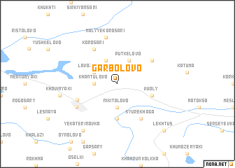
Garbolovo (Leningradskaya Oblast', Russia)Garbolovo is a town in the Leningradskaya Oblast' region of Russia. An overview map of the region around Garbolovo is displayed below.
regional and 3d topo map of Garbolovo, Russia ::
Garbolovo airports ::
The nearest airport is LED - St. Petersburg Pulkovo, located 62.7 km south of Garbolovo.
Other airports nearby include SVL - Savonlinna (196.3 km north west), Nearby towns ::
Khantulovo (1.8km west) //
Nikitolovo (3.7km south) //
Peremyaki (3.8km north) //
Putkelovo (3.8km north) //
Lavozemyaki (2.6km north west) //
Annelovo (5.6km south) //
Vuoly (3.3km south east) //
Korosari (5.9km north) //
Bol'shoye Soelo (4.6km north east) //
Kyurekhaga (5.9km south) //
Varzolovo (4.0km south west) //
Kuyvozi (4.9km south west) //
Malyye Korosari (7.5km north) //
Yekaterinovka (7.9km south) //
Lekhtus (8.3km south east) //
[all distances 'as the bird flies' and approximate]  Places with similar names to Garbolovo, Russia ::
Disclaimer :: Information on this page comes without warranty of any kind |
||
|
Where is Garbolovo? Elevation and coordinates ::
Latitude (lat): 60°21'0"N Longitude (lon): 30°30'0"E
(map arrows pan, magnifying glasses zoom) |
||
|
Visiting Garbolovo? Hotel/Accommodation ::
Book a hotel in Garbolovo Travel Guide ::
Buy a travel guide for Russia rental cars ::
car rental offers GPS waypoint ::
download a GPX waypoint (PoI) of Garbolovo for your GPS receiver
|
||