|
search place name
|
||
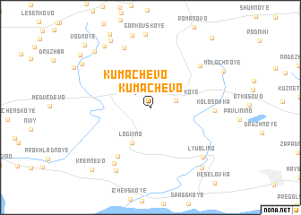
Kumachëvo (Kaliningradskaya Oblast', Russia)Kumachëvo is a town in the Kaliningradskaya Oblast' region of Russia. An overview map of the region around Kumachëvo is displayed below.
regional and 3d topo map of Kumachëvo, Russia ::
Kumachëvo airports ::
The nearest airport is KGD - Kaliningrad Khrabrovo, located 25.3 km east of Kumachëvo.
Other airports nearby include GDN - Gdansk Lecha Walesy (123.4 km west), Nearby towns ::
Kumachëvo (1.9km north west) //
Pereslavskoye (2.0km north east) //
Logvino (4.6km south) //
Cherepanovo (6.5km south) //
Kolosovka (4.6km east) //
Vetkino (7.6km north) //
Zelënyy Gay (6.3km north east) //
Shipovka (7.5km south) //
Cherepanovo (8.2km south) //
Lyublino (7.2km south east) //
Rogachevo (8.3km north west) //
Dunayevka (8.8km north) //
Dunayevka (8.1km north west) //
Lyublino (8.4km south east) //
Listopadovka (7.3km north west) //
Kremnevo (8.8km south west) //
Olʼkhovoye (8.3km north west) //
Vodnoye (9.1km north west) //
Geroyskoye (9.7km north east) //
[all distances 'as the bird flies' and approximate] 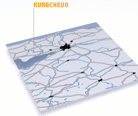 Places with similar names to Kumachëvo, Russia ::
Disclaimer :: Information on this page comes without warranty of any kind |
||
|
Where is Kumachëvo? Elevation and coordinates ::
Latitude (lat): 54°48'18"N Longitude (lon): 20°13'41"E
Elevation (approx.): 67m (map arrows pan, magnifying glasses zoom) |
||
|
Visiting Kumachëvo? Hotel/Accommodation ::
Book a hotel in Kumachëvo Travel Guide ::
Buy a travel guide for Russia rental cars ::
car rental offers GPS waypoint ::
download a GPX waypoint (PoI) of Kumachëvo for your GPS receiver
|
||