|
search place name
|
||
Podol'khovets (Tverskaya Oblast', Russia)Podol'khovets is a town in the Tverskaya Oblast' region of Russia. An overview map of the region around Podol'khovets is displayed below.
regional and 3d topo map of Podol'khovets, Russia ::

Podol'khovets airports ::
The nearest airport is KLD - Tver Migalovo, located 95.7 km south east of Podol'khovets.
Nearby towns ::
Semkino (2.6km north) //
Shchegletnya (2.6km north west) //
Shunkovo (3.9km north) //
Pochinok (4.7km south) //
Svininovo (4.7km south) //
Nozhkino (4.0km south east) //
Nivy (3.8km north west) //
Nenorovo (5.1km north) //
Politskoye (5.3km south) //
Vaybuditskaya-Gora (3.5km east) //
Sukhokhlebovo (6.5km south) //
Nikiforovo (6.8km south) //
Pryamik (4.8km north west) //
Fedovo (5.5km north west) //
Vishnëvka (6.7km north) //
Vykhodtsy (4.0km east) //
Ryskino (7.2km south) //
Krutets (7.0km south) //
Il'inskoye (6.7km south east) //
Shitovichi (7.6km south) //
Nivy Vtoryye (8.4km north) //
Yevanovo (8.0km north) //
Shilovo (5.1km north east) //
Ben'kovo (5.7km north east) //
Lipino (4.9km east) //
Yelyakovo (8.7km south) //
Pestovo (5.7km north east) //
Fedorikha (8.8km south) //
Afim'ino (6.5km north east) //
[all distances 'as the bird flies' and approximate] 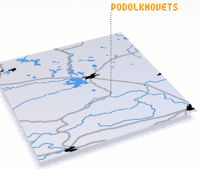 Places with similar names to Podol'khovets, Russia :: Disclaimer :: Information on this page comes without warranty of any kind |
||
|
Where is Podol'khovets? Elevation and coordinates ::
Latitude (lat): 57°25'30"N Longitude (lon): 34°37'40"E
Elevation (approx.): 185m (map arrows pan, magnifying glasses zoom) |
||
|
Visiting Podol'khovets? Hotel/Accommodation ::
Book a hotel in Podol'khovets Travel Guide ::
Buy a travel guide for Russia rental cars ::
car rental offers GPS waypoint ::
download a GPX waypoint (PoI) of Podol'khovets for your GPS receiver
|
||