|
search place name
|
||
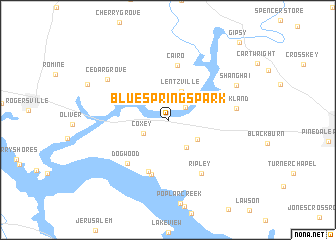
Blue Springs Park (Alabama, United States - USA)Blue Springs Park is a town in the Alabama region of United States - USA. An overview map of the region around Blue Springs Park is displayed below.
regional and 3d topo map of Blue Springs Park, United States - USA ::
Blue Springs Park airports ::
The nearest airport is HUA - Redstone Aaf, located 45.6 km east of Blue Springs Park.
Other airports nearby include BHM - Birmingham Intl (143.8 km south), BNA - Nashville Intl (151.5 km north), CBM - Colombus Columbus Afb (176.1 km south west), CHA - Chattanooga Lovell Fld (179.9 km east), Nearby towns ::
Elk Estates (2.1km north east) //
Coxey (2.7km south west) //
Lentzville (3.4km north) //
Cave Spring (3.5km south east) //
Poplar Creek (3.5km south east) //
Lazy Living Acres (6.0km south) //
Cairo (6.2km north) //
Beechwood Acres (6.3km south) //
Dogwood (6.2km south west) //
Ripley (6.7km south east) //
Oakland (6.4km east) //
Cedar Grove (7.2km north west) //
Shanghai (7.4km north east) //
Gipsy (10.9km north east) //
[all distances 'as the bird flies' and approximate] 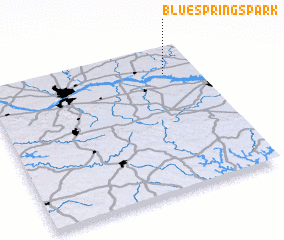 Places with similar names to Blue Springs Park, United States - USA :: Disclaimer :: Information on this page comes without warranty of any kind |
||
|
Where is Blue Springs Park? Elevation and coordinates ::
Latitude (lat): 34°48'56"N Longitude (lon): 87°9'15"W
Elevation (approx.): 183m (map arrows pan, magnifying glasses zoom) |
||
|
Visiting Blue Springs Park? Hotel/Accommodation ::
Book a hotel in Blue Springs Park Travel Guide ::
rental cars ::
car rental offers GPS waypoint ::
download a GPX waypoint (PoI) of Blue Springs Park for your GPS receiver
|
||