|
search place name
|
||
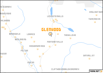
Glenwood (California, United States - USA)Glenwood is a town in the California region of United States - USA. An overview map of the region around Glenwood is displayed below.
regional and 3d topo map of Glenwood, United States - USA ::
Glenwood airports ::
The nearest airport is SJC - Norman Y Mineta San Jose Intl, located 28.7 km north of Glenwood.
Other airports nearby include NUQ - Mountain View Moffett Federal Afld (34.6 km north), SFO - San Francisco Intl (66.3 km north west), OAK - Metropolitan Oakland Intl (71.1 km north), MOD - Modesto City Co Harry Sham (107.9 km north east), Nearby towns ::
Laurel (2.0km north east) //
Fontenay Villa (3.2km south) //
Bethany Park (3.7km south) //
Holy City (5.4km north) //
Chemeketa Park (6.0km north) //
Aldercroft Heights (6.0km north) //
Lexington Hills (6.4km north) //
Zayante (5.4km west) //
Mission Springs (6.2km south west) //
The Willows (5.5km east) //
Scotts Valley (6.8km south) //
Lompico (5.9km west) //
Camp Evers (8.0km south west) //
[all distances 'as the bird flies' and approximate] 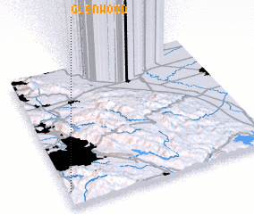 Places with similar names to Glenwood, United States - USA ::
Disclaimer :: Information on this page comes without warranty of any kind |
||
|
Where is Glenwood? Elevation and coordinates ::
Latitude (lat): 37°6'30"N Longitude (lon): 121°59'8"W
Elevation (approx.): 294m (map arrows pan, magnifying glasses zoom) |
||
|
Visiting Glenwood? Hotel/Accommodation ::
Book a hotel in Glenwood Travel Guide ::
rental cars ::
car rental offers GPS waypoint ::
download a GPX waypoint (PoI) of Glenwood for your GPS receiver
|
||