|
search place name
|
||
Lynwood Hills (California, United States - USA)Lynwood Hills is a town in the California region of United States - USA. An overview map of the region around Lynwood Hills is displayed below.
regional and 3d topo map of Lynwood Hills, United States - USA ::
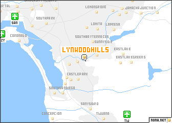
Lynwood Hills airports ::
The nearest airport is TIJ - Tijuana General Abelardo L Rodriguez Intl, located 13.8 km south east of Lynwood Hills.
Other airports nearby include SAN - San Diego Intl (16.3 km north west), NZY - San Diego North Island Nas (16.5 km west), NKX - Miramar Mcas (26.2 km north), ESE - Ensenada (103.3 km south east), Nearby towns ::
Sunny Vista (1.5km west) //
Bonita (2.5km north east) //
Lincoln Acres (3.2km north west) //
Chula Vista (3.1km west) //
Castle Park (4.2km south) //
South Bay Terraces (4.4km north) //
Sunnyside (4.6km north east) //
Harbor Side (4.8km south west) //
Boal (5.0km south west) //
Fruitdale (6.2km south west) //
Encanto (7.4km north) //
Lomita (7.4km north) //
Cockatoo Grove (6.4km east) //
Eastlake (7.0km east) //
South San Diego (8.1km south west) //
La Presa (8.6km north east) //
Imperial Beach (8.9km south west) //
South Park (11.0km north west) //
[all distances 'as the bird flies' and approximate]  Places with similar names to Lynwood Hills, United States - USA :: Disclaimer :: Information on this page comes without warranty of any kind |
||
|
Where is Lynwood Hills? Elevation and coordinates ::
Latitude (lat): 32°38'43"N Longitude (lon): 117°3'3"W
Elevation (approx.): 81m (map arrows pan, magnifying glasses zoom) |
||
|
Visiting Lynwood Hills? Hotel/Accommodation ::
Book a hotel in Lynwood Hills Travel Guide ::
rental cars ::
car rental offers GPS waypoint ::
download a GPX waypoint (PoI) of Lynwood Hills for your GPS receiver
|
||