|
search place name
|
||
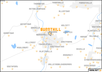
Burnt Hill (Connecticut, United States - USA)Burnt Hill is a town in the Connecticut region of United States - USA. An overview map of the region around Burnt Hill is displayed below.
regional and 3d topo map of Burnt Hill, United States - USA ::
Burnt Hill airports ::
The nearest airport is HFD - Hartford Brainard, located 36.8 km north east of Burnt Hill.
Other airports nearby include BDR - Stratford Igor I Sikorsky Mem (46.3 km south), BDL - Windsor Locks Bradley Intl (49.9 km north east), HPN - White Plains Westchester Co (79.7 km south west), CEF - Chicopee Falls Westover Arb Metropolitan (80.4 km north east), Nearby towns ::
Lakewood (0.7km north east) //
Long Hill (1.3km south east) //
Overlook (1.4km south west) //
Waterville (2.3km north west) //
Waterbury (2.3km south west) //
Fairmount (2.2km north west) //
Mill Plain (2.8km south east) //
Bunker Hill (2.5km west) //
West Side Hill (3.2km south west) //
Town Plot Hill (4.2km south) //
Fair Lawn (4.0km south east) //
Hopeville (4.8km south) //
East Mountain (5.2km south) //
Oakville (4.8km north west) //
Wolcott (5.0km north east) //
Woodtick (4.7km east) //
East Farms (5.3km south east) //
Platts Mills (6.8km south) //
Hancock (7.0km north) //
Oronoke (5.9km south west) //
Riverview Mobile Home Estates (7.2km south) //
Bradleyville (6.9km south west) //
Westview Heights (6.6km south west) //
Tolles (8.0km north) //
Hillcrest (6.6km south west) //
Union City (8.7km south) //
Glen Ridge (8.5km south) //
Allentown (9.1km north east) //
Robert Hutt Congregate Housing (9.3km south) //
[all distances 'as the bird flies' and approximate]  Places with similar names to Burnt Hill, United States - USA ::
// Bärnthal (AT)
// Burnt Hill (US)
// Bärnthal (DE)
// Birnthal (DE)
// Brünnthal (DE)
// Brunnthal (DE)
// Brunnthal (DE)
// Brant Hill (US)
// Burnt Hill (JM)
// Baerenthal (FR)
Disclaimer :: Information on this page comes without warranty of any kind |
||
|
Where is Burnt Hill? Elevation and coordinates ::
Latitude (lat): 41°34'27"N Longitude (lon): 73°2'4"W
Elevation (approx.): 210m (map arrows pan, magnifying glasses zoom) |
||
|
Visiting Burnt Hill? Hotel/Accommodation ::
Book a hotel in Burnt Hill Travel Guide ::
rental cars ::
car rental offers GPS waypoint ::
download a GPX waypoint (PoI) of Burnt Hill for your GPS receiver
|
||