|
search place name
|
||
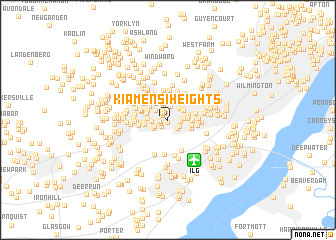
Kiamensi Heights (Delaware, United States - USA)Kiamensi Heights is a town in the Delaware region of United States - USA. An overview map of the region around Kiamensi Heights is displayed below.
regional and 3d topo map of Kiamensi Heights, United States - USA ::
Kiamensi Heights airports ::
The nearest airport is ILG - Wilmington New Castle, located 5.1 km south east of Kiamensi Heights.
Other airports nearby include PHL - Philadelphia Intl (37.6 km north east), APG - Aberdeen Phillips Aaf (53.9 km south west), MIV - Millville Muni (62.1 km south east), DOV - Dover Afb (67.1 km south), Nearby towns ::
Glen Berne Estates (0.3km south) //
Kiamensi Gardens (0.6km north west) //
Marshallton Heights II (0.7km north west) //
Kiamensi (0.8km north west) //
Westfield (0.7km west) //
Stanton (0.8km south west) //
Washington Heights (0.9km north west) //
Glenville (1.0km south west) //
Marshallton Green (1.2km north west) //
Tuxedo Park (1.1km east) //
Pleasant Hills (1.2km south east) //
Silview (1.2km south east) //
Cranston Heights (1.6km north) //
Duncan Village (1.6km north) //
Stanton Estates (1.4km south west) //
Westview (1.3km east) //
Avalon (1.6km north east) //
Capital Trail Farms (1.5km north west) //
Arbor Pointe Apartments (1.5km south west) //
Cedar Heights (1.4km east) //
Rolling Hills (1.4km west) //
Duncan Woods (1.9km north) //
Belvidere (1.5km east) //
Landenberg Junction (1.7km north east) //
Liberty (1.7km north east) //
Masonicville (1.7km east) //
Greenbank (2.2km north) //
Prices Corner (2.2km north east) //
Dunlinden Acres (2.1km north west) //
[all distances 'as the bird flies' and approximate]  Places with similar names to Kiamensi Heights, United States - USA :: Disclaimer :: Information on this page comes without warranty of any kind |
||
|
Where is Kiamensi Heights? Elevation and coordinates ::
Latitude (lat): 39°43'10"N Longitude (lon): 75°38'0"W
Elevation (approx.): 10m (map arrows pan, magnifying glasses zoom) |
||
|
Visiting Kiamensi Heights? Hotel/Accommodation ::
Book a hotel in Kiamensi Heights Travel Guide ::
rental cars ::
car rental offers GPS waypoint ::
download a GPX waypoint (PoI) of Kiamensi Heights for your GPS receiver
|
||