|
search place name
|
||
Terre Haute (Iowa, United States - USA)Terre Haute is a town in the Iowa region of United States - USA. An overview map of the region around Terre Haute is displayed below.
regional and 3d topo map of Terre Haute, United States - USA ::

Terre Haute airports ::
The nearest airport is DSM - Des Moines Intl, located 96.0 km north of Terre Haute.
Other airports nearby include MCI - Kansas City Intl (170.0 km south west), FLV - Fort Leavenworth Sherman Aaf (171.2 km south west), FOD - Fort Dodge Rgnl (209.2 km north), SZL - Knobnoster Whiteman Afb (218.6 km south), Nearby towns ::
Barrell (1.6km north) //
Decatur City (7.1km north east) //
Davis City (6.8km south east) //
Lamoni (8.8km south west) //
[all distances 'as the bird flies' and approximate] 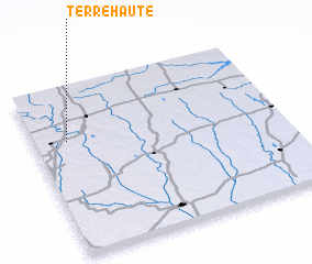 Places with similar names to Terre Haute, United States - USA ::
// Tara Huta (BO)
// Tarhaout (MA)
// Tarhat (MA)
// Tourhat (MA)
// Terra Haute (US)
// Terre Haute (US)
// Terre Haute (US)
// Deerhead (US)
// Terheide (DE)
// Ytre Hoddøy (NO)
Disclaimer :: Information on this page comes without warranty of any kind |
||
|
Where is Terre Haute? Elevation and coordinates ::
Latitude (lat): 40°41'0"N Longitude (lon): 93°51'59"W
Elevation (approx.): 278m (map arrows pan, magnifying glasses zoom) |
||
|
Visiting Terre Haute? Hotel/Accommodation ::
Book a hotel in Terre Haute Travel Guide ::
rental cars ::
car rental offers GPS waypoint ::
download a GPX waypoint (PoI) of Terre Haute for your GPS receiver
|
||