|
search place name
|
||
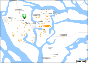
Gay Oaks (South Carolina, United States - USA)Gay Oaks is a town in the South Carolina region of United States - USA. An overview map of the region around Gay Oaks is displayed below.
regional and 3d topo map of Gay Oaks, United States - USA ::
Gay Oaks airports ::
The nearest airport is NBC - Beaufort Mcas, located 9.6 km north west of Gay Oaks.
Other airports nearby include SAV - Savannah Hilton Head Intl (61.3 km south west), SVN - Hunter Aaf (65.1 km south west), CHS - Charleston Afb Intl (78.1 km north east), AGS - Bush Field Augusta Rgnl At Bush Fld (162.2 km north west), Nearby towns ::
Sherwood Forest (0.4km south east) //
Oakwood Park (0.7km north east) //
Red Oak (1.0km south west) //
Sangster Village (1.4km west) //
Hazel Farm (1.6km south west) //
Academy Estates (2.1km north east) //
Bluff Farm (2.2km north) //
Yacht Club Estates (2.1km south west) //
Blue Heron Bluff (2.4km north) //
Orange Grove (2.4km south west) //
Beaufort (2.5km north west) //
Quail Run (2.8km north) //
Country Club Bluff (2.8km north) //
Morgan River Estates (2.7km north east) //
Colony Gardens Estates (3.0km north) //
Pine Hill Acres (3.3km north) //
Marsh Harbor (3.4km north) //
Port Royal Landing (3.9km south west) //
Ashdale (4.3km north east) //
Riverwind (4.2km south west) //
Partridge Woods (4.9km north) //
Waterford Place (4.6km south west) //
Royal Pines Country Club Estates (5.2km north) //
Walnut Hill (5.6km north) //
Attaway (5.8km north) //
Mariners Watch (5.8km south west) //
Salem Plantation (5.4km west) //
Polk Village (5.7km north west) //
Port Royal (6.0km south west) //
[all distances 'as the bird flies' and approximate]  Places with similar names to Gay Oaks, United States - USA ::
Disclaimer :: Information on this page comes without warranty of any kind |
||
|
Where is Gay Oaks? Elevation and coordinates ::
Latitude (lat): 32°25'5"N Longitude (lon): 80°38'55"W
Elevation (approx.): 16m (map arrows pan, magnifying glasses zoom) |
||
|
Visiting Gay Oaks? Hotel/Accommodation ::
Book a hotel in Gay Oaks Travel Guide ::
rental cars ::
car rental offers GPS waypoint ::
download a GPX waypoint (PoI) of Gay Oaks for your GPS receiver
|
||