|
search place name
|
||
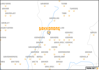
Dak Kơnong (Vietnam)Dak Kơnong is a town in Vietnam. An overview map of the region around Dak Kơnong is displayed below.
regional and 3d topo map of Dak Kơnong, Vietnam ::
Dak Kơnong airports ::
The nearest airport is DAD - Danang Intl, located 141.3 km north of Dak Kơnong.
Nearby towns ::
Dak Honjro (1.9km south) //
Dak Mong (2.6km south east) //
Dak Pơlai (1) (4.0km north east) //
Dak Ha (2) (4.0km south east) //
Dak Gô (4.1km south west) //
Dak Ben (4.0km north west) //
Kon Hơnong (4.0km south west) //
Dak Klang (2) (5.2km south east) //
Dak Pha (5.2km south west) //
Dak Kơsan (5.6km south) //
Dak Pơlai (3) (5.8km north) //
Kon Pơ (5.8km south) //
Dak Ha (1) (5.7km east) //
Kon Kre (2) (7.2km east) //
Dak Jrong (7.6km south) //
Kon Pia (3) (7.4km east) //
Dak Haô (7.6km south) //
Dak Kơsa Peng (7.7km south west) //
Kon Pia (2) (8.1km south east) //
Taba (9.2km north east) //
Kon Pao Kram (9.2km south east) //
Dak Rơsa (9.2km south west) //
Dakrekat (10.3km north east) //
[all distances 'as the bird flies' and approximate] 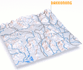 Places with similar names to Dak Kơnong, Vietnam ::
// Takaneng (ZA)
// Takoning (ID)
// Tokonanaka (ID)
// Doconing (AU)
// Daganang (MM)
// Htiganaing (MM)
Disclaimer :: Information on this page comes without warranty of any kind |
||
|
Where is Dak Kơnong? Elevation and coordinates ::
Latitude (lat): 14°48'0"N Longitude (lon): 107°54'0"E
Elevation (approx.): 1050m (map arrows pan, magnifying glasses zoom) |
||
|
Visiting Dak Kơnong? Hotel/Accommodation ::
Book a hotel in Dak Kơnong Travel Guide ::
Buy a travel guide for Vietnam rental cars ::
car rental offers GPS waypoint ::
download a GPX waypoint (PoI) of Dak Kơnong for your GPS receiver
|
||