|
search place name
|
||
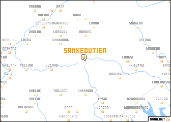
Sam Keou Tien (Quảng Ninh, Vietnam)Sam Keou Tien is a town in the Quảng Ninh region of Vietnam. An overview map of the region around Sam Keou Tien is displayed below.
regional and 3d topo map of Sam Keou Tien, Vietnam ::
Sam Keou Tien airports ::
The nearest airport is NNG - Nanning Wuxu, located 138.5 km north east of Sam Keou Tien.
Other airports nearby include HAN - Hanoi Noibai Intl (183.4 km west), Nearby towns ::
Na Mang (5.6km north) //
Dinh Duong (6.4km north west) //
Khê Khoai (7.4km south) //
Luc Nhu (7.1km west) //
Co Hoa (7.6km north) //
Long Way (7.6km north west) //
Vong Mao Khy (7.8km south east) //
Tam Lang (9.0km south west) //
Ngan Kheo (9.0km north west) //
[all distances 'as the bird flies' and approximate]  Places with similar names to Sam Keou Tien, Vietnam ::
// Zmogotin (RO)
// Saimekadın (TR)
// Smoketown (US)
// Smoketown (US)
// Smoketown (US)
// Smoketown (US)
// Smoketown (US)
// Samuka Town (LR)
// Xóm Cả Dinh (VN)
// Smakhtino (RU)
Disclaimer :: Information on this page comes without warranty of any kind |
||
|
Where is Sam Keou Tien? Elevation and coordinates ::
Latitude (lat): 21°30'0"N Longitude (lon): 107°33'0"E
Elevation (approx.): 597m (map arrows pan, magnifying glasses zoom) |
||
|
Visiting Sam Keou Tien? Hotel/Accommodation ::
Book a hotel in Sam Keou Tien Travel Guide ::
Buy a travel guide for Vietnam rental cars ::
car rental offers GPS waypoint ::
download a GPX waypoint (PoI) of Sam Keou Tien for your GPS receiver
|
||