|
search place name
|
||
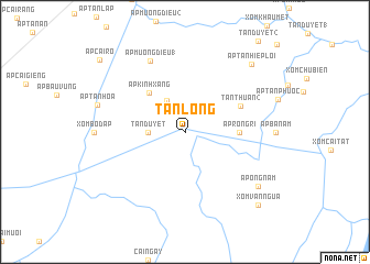
Tân Long (Minh Hải, Vietnam)Tân Long is a town in the Minh Hải region of Vietnam. An overview map of the region around Tân Long is displayed below.
regional and 3d topo map of Tân Long, Vietnam ::
Tân Long airports ::
The nearest airport is SGN - Ho Chi Minh City Tansonnhat Intl, located 258.0 km north east of Tân Long.
Nearby towns ::
Ấp Tân Ðiền (1) (3.6km north west) //
Tân Ðuyệt (3.7km west) //
Ấp Kinh Xáng (5.4km north west) //
Ấp Rồng Ri (5.5km east) //
Tân Thuận (2) (6.2km north east) //
Ấp Mương Ðiều (1) (8.0km north west) //
Ấp Tân Hòa (9.2km west) //
Ấp Ông Năm (9.2km south east) //
Ấp Tân Hiệp Lợi (9.6km north east) //
Xóm Ván Ngừa (10.4km south east) //
Ấp Cái Rô (11.2km north west) //
[all distances 'as the bird flies' and approximate]  Places with similar names to Tân Long, Vietnam ::
// Danilenki (RU)
// Tai'anling (CN)
// T'ien-leng (TW)
// Ðình Làng (VN)
// Ðôn Lương (VN)
// Dồn Lưống (VN)
// Tanolang (PH)
// Tanolong (PH)
// Tân Long (VN)
// Tân Long (VN)
Disclaimer :: Information on this page comes without warranty of any kind |
||
|
Where is Tân Long? Elevation and coordinates ::
Latitude (lat): 8°59'0"N Longitude (lon): 105°12'0"E
Elevation (approx.): 4m (map arrows pan, magnifying glasses zoom) |
||
|
Visiting Tân Long? Hotel/Accommodation ::
Book a hotel in Tân Long Travel Guide ::
Buy a travel guide for Vietnam rental cars ::
car rental offers GPS waypoint ::
download a GPX waypoint (PoI) of Tân Long for your GPS receiver
|
||