|
search place name
|
||
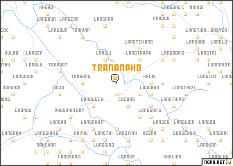
Trân An Phố (Vietnam)Trân An Phố is a town in Vietnam. An overview map of the region around Trân An Phố is displayed below.
regional and 3d topo map of Trân An Phố, Vietnam ::
Trân An Phố airports ::
The nearest airport is HAN - Hanoi Noibai Intl, located 185.0 km south east of Trân An Phố.
Nearby towns ::
Làng Cú (1.9km south) //
Làng Lân (2.5km north west) //
Bảo Hà (2.5km north east) //
Làng Li (4.1km north west) //
Làng Tóc (3.9km north west) //
Ngòi Lúc (3.9km north east) //
Làng Khe Quất (3.9km south east) //
Côc Bào (4.1km south east) //
Làng Thap (1) (5.1km north east) //
Làng Uêch (5.1km south west) //
Ké Lai (5.1km east) //
Tầm Song (5.1km west) //
Làng Bùn (5.5km east) //
Khe Ngày (5.5km east) //
Làng Cao Bàn (6.5km south east) //
Làng Tchang (6.5km north east) //
Làng Hồng (6.3km south east) //
Kuoi Tầm Bào (7.4km south) //
Bản Ðam (6.9km east) //
Làng Sang (7.6km south east) //
Bài Thượng (7.8km north east) //
Làng Phàn (8.2km south west) //
Phú Sinh Ngày (8.8km south west) //
Trại Van (9.0km north west) //
Kuoi Sàn (9.0km south east) //
Làng Co (10.1km south east) //
[all distances 'as the bird flies' and approximate] 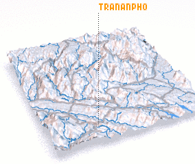 Places with similar names to Trân An Phố, Vietnam ::
// Torano Nuovo (IT)
// Derreenannagh (IE)
Disclaimer :: Information on this page comes without warranty of any kind |
||
|
Where is Trân An Phố? Elevation and coordinates ::
Latitude (lat): 22°10'0"N Longitude (lon): 104°20'0"E
Elevation (approx.): 159m (map arrows pan, magnifying glasses zoom) |
||
|
Visiting Trân An Phố? Hotel/Accommodation ::
Book a hotel in Trân An Phố Travel Guide ::
Buy a travel guide for Vietnam rental cars ::
car rental offers GPS waypoint ::
download a GPX waypoint (PoI) of Trân An Phố for your GPS receiver
|
||