|
search place name
|
||
Xóm Ðôi Chuong (Thanh Hóa, Vietnam)Xóm Ðôi Chuong is a town in the Thanh Hóa region of Vietnam. An overview map of the region around Xóm Ðôi Chuong is displayed below.
regional and 3d topo map of Xóm Ðôi Chuong, Vietnam ::

Xóm Ðôi Chuong airports ::
The nearest airport is HAN - Hanoi Noibai Intl, located 104.4 km north east of Xóm Ðôi Chuong.
Nearby towns ::
Xóm Dy (1.7km west) //
Xóm Chần (1.9km south) //
Xóm Biên (2.5km south west) //
Xóm Xương (3.7km north) //
Xóm Mô (3.7km north) //
Nội Sá (3.7km south) //
Xóm Sài (3.9km south east) //
Xóm Khải (5.1km north west) //
Xóm Cã (5.1km south west) //
Xóm Kiến (5.2km west) //
Xóm Mât (5.6km south) //
Xóm Tieng (5.6km north) //
Xóm Ấm (5.5km west) //
Xóm Chinh (6.6km south west) //
Xóm Xot (6.6km north east) //
Làng Boi (7.4km north) //
Làng Ðam (7.6km north) //
Xóm Khu Thương (7.2km east) //
Xóm Xương (7.6km south) //
Làng Mon (7.6km north west) //
Xóm Mậc (9.1km south east) //
Làng Troi (8.9km north east) //
Chí Gao (10.2km north west) //
Thạch Lũ (10.2km south west) //
[all distances 'as the bird flies' and approximate] 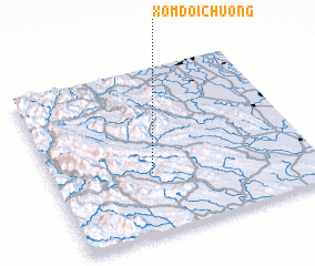 Places with similar names to Xóm Ðôi Chuong, Vietnam :: Disclaimer :: Information on this page comes without warranty of any kind |
||
|
Where is Xóm Ðôi Chuong? Elevation and coordinates ::
Latitude (lat): 20°22'0"N Longitude (lon): 105°23'0"E
Elevation (approx.): 106m (map arrows pan, magnifying glasses zoom) |
||
|
Visiting Xóm Ðôi Chuong? Hotel/Accommodation ::
Book a hotel in Xóm Ðôi Chuong Travel Guide ::
Buy a travel guide for Vietnam rental cars ::
car rental offers GPS waypoint ::
download a GPX waypoint (PoI) of Xóm Ðôi Chuong for your GPS receiver
|
||