|
search place name
|
||
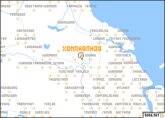
Xóm Nhăn Hoa (Vietnam)Xóm Nhăn Hoa is a town in Vietnam. An overview map of the region around Xóm Nhăn Hoa is displayed below.
regional and 3d topo map of Xóm Nhăn Hoa, Vietnam ::
Xóm Nhăn Hoa airports ::
The nearest airport is SNO - Sakon Nakhon, located 239.5 km south west of Xóm Nhăn Hoa.
Nearby towns ::
Tam Ða (0.0km north) //
Phương Tích (0.0km north) //
Hung Vân (1.9km north) //
Kim Khê (1.8km east) //
Trung Hậu (1.9km south) //
Xuân Mỹ (1.8km west) //
Vân Trính (1.8km west) //
Tam Ða (2.6km north west) //
Làng Ðưc Thành (2.6km south east) //
Yên Lac (1) (3.7km south) //
Xã Ðoài (1) (3.7km south) //
Vong Nhi (4.0km north east) //
Làng Nam Doai (4.0km south east) //
Làng Ðiên Cat (4.0km south east) //
Ngọc Lien (4.1km south east) //
Mỹ Yên (4.0km south west) //
Hà Thanh (4.0km south west) //
Mỹ Hòa (4.0km south west) //
Ðông Thôn (4.1km south west) //
Thiều Xá (1) (4.1km south west) //
La Nham (5.1km north east) //
Xóm Van Hanh (5.1km south east) //
Tung Thôn (5.1km south west) //
Bui Thôn (5.1km south west) //
Mỹ Xa (5.6km east) //
Vân Trinh (5.6km west) //
Lò Vân (5.8km north) //
Tuy Anh (5.6km west) //
Kim Khê (5.6km east) //
[all distances 'as the bird flies' and approximate]  Places with similar names to Xóm Nhăn Hoa, Vietnam ::
// Xóm Nhân Hòa (VN)
// Xóm Nhuan Ha (VN)
Disclaimer :: Information on this page comes without warranty of any kind |
||
|
Where is Xóm Nhăn Hoa? Elevation and coordinates ::
Latitude (lat): 18°49'0"N Longitude (lon): 105°37'0"E
Elevation (approx.): 12m (map arrows pan, magnifying glasses zoom) |
||
|
Visiting Xóm Nhăn Hoa? Hotel/Accommodation ::
Book a hotel in Xóm Nhăn Hoa Travel Guide ::
Buy a travel guide for Vietnam rental cars ::
car rental offers GPS waypoint ::
download a GPX waypoint (PoI) of Xóm Nhăn Hoa for your GPS receiver
|
||