|
search place name
|
||
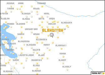
Al Ahdīyah (‘Adan, Yemen)Al Ahdīyah is a town in the ‘Adan region of Yemen. An overview map of the region around Al Ahdīyah is displayed below.
regional and 3d topo map of Al Ahdīyah, Yemen ::
Nearby towns ::
Şabrah (1.6km north west) //
Tarābin (1.9km south) //
Bakayn (1.8km east) //
Al Ajil (2.6km north east) //
Sharaf (2.9km north west) //
Qush‘ah (3.7km north) //
Maklān (3.7km north) //
Al Jamīmah (4.0km north west) //
Jabāb (4.0km north west) //
Az̧ Z̧āhirah (4.0km south west) //
Kharbaj (4.1km north east) //
Al Qāmah (4.1km north east) //
As Surraha (4.1km north west) //
‘Arshī (4.1km south west) //
Marāt (4.1km south west) //
Al Bidh (4.0km north east) //
‘Ardinah (4.6km south) //
Al Maridmy (5.0km south east) //
Ḩawādid (5.2km north west) //
Arḑah (5.4km west) //
Wāqid (5.6km north) //
As Saram (5.6km north) //
Hudarah (5.8km north) //
Arhab (5.7km west) //
As Sala (5.8km north) //
Ar Ribāţ (5.8km north) //
Al Fuqahāʼ (6.3km south west) //
‘Awābil (6.3km north west) //
Qatid (6.6km north west) //
[all distances 'as the bird flies' and approximate]  Places with similar names to Al Ahdīyah, Yemen ::
// Alutoya (LK)
// Al ‘Ayyādīyah (EG)
// Al ‘Ayyādīyah (EG)
// Aldaya (ES)
// Al'diya (RU)
// Al ‘Aţāyā (SA)
// Al ‘Aţāyā (SD)
// Al ‘Ādīyah (YE)
// Al ‘Ādīyah (YE)
// Al ‘Ādīyah (YE)
Disclaimer :: Information on this page comes without warranty of any kind |
||
|
Where is Al Ahdīyah? Elevation and coordinates ::
Latitude (lat): 13°48'0"N Longitude (lon): 44°54'0"E
Elevation (approx.): 1917m (map arrows pan, magnifying glasses zoom) |
||
|
Visiting Al Ahdīyah? Hotel/Accommodation ::
Book a hotel in Al Ahdīyah Travel Guide ::
Buy a travel guide for Yemen rental cars ::
car rental offers GPS waypoint ::
download a GPX waypoint (PoI) of Al Ahdīyah for your GPS receiver
|
||