|
search place name
|
||
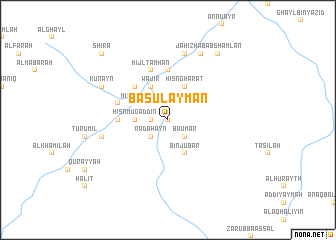
Bā Sulaymān (‘Adan, Yemen)Bā Sulaymān is a town in the ‘Adan region of Yemen. An overview map of the region around Bā Sulaymān is displayed below.
regional and 3d topo map of Bā Sulaymān, Yemen ::
Nearby towns ::
Ash Sharāqī (0.0km north) //
Al Jabūb (0.0km north) //
Shu‘bah (1.9km north) //
Az Zāhir (1.8km west) //
Khilbah (1.8km west) //
Bā ‘Umar (2.6km south east) //
Radaḩayn (2.6km south west) //
Ḩişn Mugaddin (3.6km west) //
Bā Wāqid (4.1km south east) //
Bin Jubār (4.1km south east) //
Mubārak (4.0km north west) //
Bā Zar‘ah (4.0km north west) //
Ḩişn Ghārāt (4.1km north east) //
Wājir (4.1km north west) //
Maşāni‘ (4.1km north west) //
Saman (5.2km north west) //
Dibāb (5.2km north west) //
Habrah (5.6km north) //
Qarn Bā Mas‘ūd (5.4km west) //
Ash Sharāqī (5.4km west) //
Ḩijl Ţamḩān (5.8km north) //
Makīyah (5.7km west) //
Ribāţ Bā Kawbal (7.4km west) //
Jāḩiz (7.6km north) //
Dār Dhirab (7.6km north) //
‘Amd (8.2km north east) //
Kunayn (8.1km north west) //
Habab Shamlān (9.2km north east) //
Shira‘ (10.3km north west) //
[all distances 'as the bird flies' and approximate]  Places with similar names to Bā Sulaymān, Yemen ::
Disclaimer :: Information on this page comes without warranty of any kind |
||
|
Where is Bā Sulaymān? Elevation and coordinates ::
Latitude (lat): 15°14'0"N Longitude (lon): 47°57'0"E
Elevation (approx.): 1300m (map arrows pan, magnifying glasses zoom) |
||
|
Visiting Bā Sulaymān? Hotel/Accommodation ::
Book a hotel in Bā Sulaymān Travel Guide ::
Buy a travel guide for Yemen rental cars ::
car rental offers GPS waypoint ::
download a GPX waypoint (PoI) of Bā Sulaymān for your GPS receiver
|
||