|
search place name
|
||
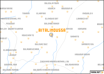
Aït Ali Moussa (Safi, Morocco)Aït Ali Moussa is a town in the Safi region of Morocco. An overview map of the region around Aït Ali Moussa is displayed below.
regional and 3d topo map of Aït Ali Moussa, Morocco ::
Aït Ali Moussa airports ::
The nearest airport is RAK - Marrakech Menara, located 87.4 km south east of Aït Ali Moussa.
Other airports nearby include AGA - Agadir Inezgane (185.6 km south), CMN - Casablanca Mohammed V Intl (197.6 km north east), OZZ - Ouarzazate (217.2 km south east), Nearby towns ::
El Heïdate (1.5km east) //
Mohammed Ben Hasbia (1.6km east) //
Salem Ben Amer (3.7km north) //
Layaïda (3.7km north) //
Ouled Azouz (4.9km south west) //
El Khouissat (5.6km north) //
Douar Ben Zaïter (5.8km south) //
El Kherheb (5.1km east) //
Douar Abd el Hajj (5.1km west) //
Douar Bou Ali (5.1km west) //
El Hafaïa (8.1km north west) //
Smahate (7.2km east) //
Mouichnate (7.3km west) //
Oulad Bou Chaïb (8.4km south west) //
[all distances 'as the bird flies' and approximate] 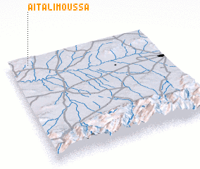 Places with similar names to Aït Ali Moussa, Morocco ::
Disclaimer :: Information on this page comes without warranty of any kind |
||
|
Where is Aït Ali Moussa? Elevation and coordinates ::
Latitude (lat): 31°57'0"N Longitude (lon): 8°52'0"W
Elevation (approx.): 579m (map arrows pan, magnifying glasses zoom) |
||
|
Visiting Aït Ali Moussa? Hotel/Accommodation ::
Book a hotel in Aït Ali Moussa Travel Guide ::
Buy a travel guide for Morocco rental cars ::
car rental offers GPS waypoint ::
download a GPX waypoint (PoI) of Aït Ali Moussa for your GPS receiver
|
||