|
search place name
|
||
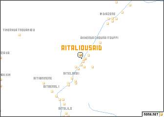
Aït Ali Ou Säid (Ouarzazate, Morocco)Aït Ali Ou Säid is a town in the Ouarzazate region of Morocco. An overview map of the region around Aït Ali Ou Säid is displayed below.
regional and 3d topo map of Aït Ali Ou Säid, Morocco ::
Aït Ali Ou Säid airports ::
The nearest airport is OZZ - Ouarzazate, located 110.3 km south west of Aït Ali Ou Säid.
Other airports nearby include ERH - Er-rachidia Moulay Ali Cherif (155.6 km east), CMN - Casablanca Mohammed V Intl (257.9 km north west), Nearby towns ::
Aït Ouaddar (0.4km east) //
Aït Bou Houkou (0.8km south) //
Aït Oudinar (0.7km east) //
Aït Idaïr (1.5km south) //
Aït Outfi (1.4km north east) //
Aït Ouhahi (2.0km south) //
Aït Aïssi (2.3km south west) //
Zouiet Sidi Daoud (2.5km south) //
Aït Ali Ou Haj (2.8km south east) //
Aït el Arbi (4.9km south west) //
Aït Ouglif (5.3km south) //
Akhendachou nʼAït Ouffi (5.1km north east) //
Imzoudar (5.8km south) //
Tamellalt (6.3km south west) //
Zouiet Sidi Bou Beker (6.6km south west) //
Tirbadouine (9.4km north east) //
Aït Ben Ali (9.6km south west) //
Aït Youl (10.0km south west) //
Aït Ibrirene (9.4km south west) //
Aït Saïd (10.4km north east) //
[all distances 'as the bird flies' and approximate]  Places with similar names to Aït Ali Ou Säid, Morocco ::
// Aït Ali Ou Saïd (MA)
Disclaimer :: Information on this page comes without warranty of any kind |
||
|
Where is Aït Ali Ou Säid? Elevation and coordinates ::
Latitude (lat): 31°30'4"N Longitude (lon): 5°57'16"W
Elevation (approx.): 1733m (map arrows pan, magnifying glasses zoom) |
||
|
Visiting Aït Ali Ou Säid? Hotel/Accommodation ::
Book a hotel in Aït Ali Ou Säid Travel Guide ::
Buy a travel guide for Morocco rental cars ::
car rental offers GPS waypoint ::
download a GPX waypoint (PoI) of Aït Ali Ou Säid for your GPS receiver
|
||