|
search place name
|
||
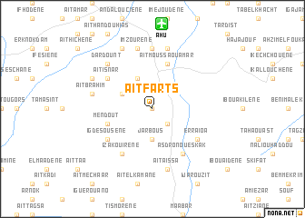
Aït Farts (Al Hoceïma, Morocco)Aït Farts is a town in the Al Hoceïma region of Morocco. An overview map of the region around Aït Farts is displayed below.
regional and 3d topo map of Aït Farts, Morocco ::
Aït Farts airports ::
The nearest airport is AHU - Al Hociema Cherif El Idrissi, located 10.4 km north of Aït Farts.
Other airports nearby include MLN - Melilla (84.3 km east), TTU - Tetouan Saniat Rmel (145.2 km north west), FEZ - Fez Saiss (164.9 km south west), OUD - Oujda Angads (179.0 km east), Nearby towns ::
Irhmîrene (0.0km north) //
Tasograt (2.4km south east) //
Jarbous (3.7km south) //
Aït Dara (3.6km north west) //
Bouselama (4.0km north) //
Mendout (4.9km west) //
Aït Moussa Ou Amar (5.8km north) //
Izakouirene (6.3km south west) //
Asdro Noueskak (6.3km south east) //
Igdesousene (5.9km south west) //
Eddouiene (5.9km south west) //
Erraioa (5.9km south east) //
Aït Isnar (5.9km north west) //
Einzorene (7.4km north) //
Aït Aïssa (7.6km south) //
Aït Saïd (7.6km north) //
Imzoûrene (7.6km north) //
Aït Brahim (6.3km west) //
Dardount (7.2km north west) //
Tigart (8.0km north) //
Aït Amar Ou Saïd (7.1km north west) //
[all distances 'as the bird flies' and approximate]  Places with similar names to Aït Farts, Morocco ::
// Advoritsa (RU)
Disclaimer :: Information on this page comes without warranty of any kind |
||
|
Where is Aït Farts? Elevation and coordinates ::
Latitude (lat): 35°5'0"N Longitude (lon): 3°51'0"W
Elevation (approx.): 333m (map arrows pan, magnifying glasses zoom) |
||
|
Visiting Aït Farts? Hotel/Accommodation ::
Book a hotel in Aït Farts Travel Guide ::
Buy a travel guide for Morocco rental cars ::
car rental offers GPS waypoint ::
download a GPX waypoint (PoI) of Aït Farts for your GPS receiver
|
||