|
search place name
|
||
Bouir Chleh (Marrakech, Morocco)Bouir Chleh is a town in the Marrakech region of Morocco. An overview map of the region around Bouir Chleh is displayed below.
regional and 3d topo map of Bouir Chleh, Morocco ::

Bouir Chleh airports ::
The nearest airport is RAK - Marrakech Menara, located 37.5 km south east of Bouir Chleh.
Other airports nearby include OZZ - Ouarzazate (164.9 km south east), CMN - Casablanca Mohammed V Intl (173.6 km north), AGA - Agadir Inezgane (209.8 km south west), Nearby towns ::
Bouhane (1.9km south) //
Drana (4.0km south west) //
Mesret (3.7km south east) //
Douar Oulad Ahmida (4.7km west) //
Et Touanessa (6.4km north east) //
Tleta des Oulad Dlim (6.4km north west) //
Kerkouz (7.6km south) //
Sidi-Drharhi (7.6km south) //
Hamida (6.6km west) //
Oulad Lahsene (7.3km north east) //
Jdouarate (8.1km north east) //
El-Arouga (8.8km north east) //
[all distances 'as the bird flies' and approximate] 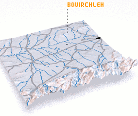 Places with similar names to Bouir Chleh, Morocco ::
// Brecholey (CH)
// Barchel (DE)
// Borchel (DE)
// Bracial (PT)
// Bīrīshūl (IR)
// Būrā Chālū (IR)
// Brush Hollow (US)
// Berch Hole (US)
// Brush Hill (US)
// Bara Chāla (BD)
Disclaimer :: Information on this page comes without warranty of any kind |
||
|
Where is Bouir Chleh? Elevation and coordinates ::
Latitude (lat): 31°54'0"N Longitude (lon): 8°14'0"W
Elevation (approx.): 577m (map arrows pan, magnifying glasses zoom) |
||
|
Visiting Bouir Chleh? Hotel/Accommodation ::
Book a hotel in Bouir Chleh Travel Guide ::
Buy a travel guide for Morocco rental cars ::
car rental offers GPS waypoint ::
download a GPX waypoint (PoI) of Bouir Chleh for your GPS receiver
|
||