|
search place name
|
||
Had des Mjatt (Marrakech, Morocco)Had des Mjatt is a town in the Marrakech region of Morocco. An overview map of the region around Had des Mjatt is displayed below.
regional and 3d topo map of Had des Mjatt, Morocco ::

Had des Mjatt airports ::
The nearest airport is RAK - Marrakech Menara, located 52.5 km north east of Had des Mjatt.
Other airports nearby include AGA - Agadir Inezgane (146.8 km south west), OZZ - Ouarzazate (158.4 km east), Nearby towns ::
Souq at Had Mejjat (0.0km north) //
Aït Lalloud (1.9km south) //
Aït Tahar (3.7km north) //
Aït Larbi (3.2km west) //
El Ouljat (3.7km south) //
Aït Abaïd (4.0km south east) //
El Jorf (4.9km south east) //
El Mrarcha (5.6km north) //
Aït Bella (5.8km north) //
Dehrat (5.8km south) //
Aït Amane (6.0km north west) //
Dar Akimakh (6.4km south east) //
Tiguemmi Oumrar (6.4km south west) //
Tamatoust (7.4km south) //
Staïli (7.6km north) //
Sbaït (7.6km north) //
Irhil (6.6km east) //
Zinebt (6.6km east) //
Akimakh (7.3km south east) //
Tihouchi (7.8km south west) //
Taguenza (8.8km south west) //
[all distances 'as the bird flies' and approximate] 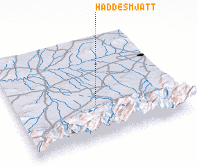 Places with similar names to Had des Mjatt, Morocco :: Disclaimer :: Information on this page comes without warranty of any kind |
||
|
Where is Had des Mjatt? Elevation and coordinates ::
Latitude (lat): 31°21'0"N Longitude (lon): 8°30'0"W
Elevation (approx.): 630m (map arrows pan, magnifying glasses zoom) |
||
|
Visiting Had des Mjatt? Hotel/Accommodation ::
Book a hotel in Had des Mjatt Travel Guide ::
Buy a travel guide for Morocco rental cars ::
car rental offers GPS waypoint ::
download a GPX waypoint (PoI) of Had des Mjatt for your GPS receiver
|
||