|
search place name
|
||
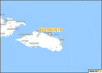
Buenavista (Albay, Philippines)Buenavista is a town in the Albay region of Philippines. An overview map of the region around Buenavista is displayed below.
regional and 3d topo map of Buenavista, Philippines ::
Buenavista airports ::
The nearest airport is TAC - Tacloban Daniel Z Romualdez, located 238.7 km south east of Buenavista.
Other airports nearby include KLO - Kalibo (259.9 km south west), Nearby towns ::
Agojo (1.4km west) //
Viga (1.9km east) //
Tinopan (1.9km east) //
Mananao (4.2km west) //
Linao (4.3km south east) //
Malobago (4.4km south east) //
Carogcog (4.4km south) //
Binosauan (4.4km south east) //
Nagcalsot (6.6km south west) //
Cagabae (6.6km south west) //
Rapu-Rapu (6.9km south west) //
Buhatan (8.1km south west) //
Bagaubauan (8.1km south west) //
Masaga (8.1km south west) //
[all distances 'as the bird flies' and approximate] 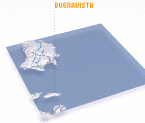 Places with similar names to Buenavista, Philippines ::
// Buenavista (PH)
// Buenavista (PH)
// Buenavista (PH)
// Buenavista (PH)
// Buenavista (PH)
// Buena Vista (PH)
// Buena Vista (PH)
// Buena Vista (PH)
// Buenavista (PH)
// Buenavista (PH)
Disclaimer :: Information on this page comes without warranty of any kind |
||
|
Where is Buenavista? Elevation and coordinates ::
Latitude (lat): 13°13'7"N Longitude (lon): 124°10'56"E
Elevation (approx.): 14m (map arrows pan, magnifying glasses zoom) |
||
|
Visiting Buenavista? Hotel/Accommodation ::
Book a hotel in Buenavista Travel Guide ::
Buy a travel guide for Philippines rental cars ::
car rental offers GPS waypoint ::
download a GPX waypoint (PoI) of Buenavista for your GPS receiver
|
||