|
search place name
|
||
Santa Rosario (Bohol, Philippines)Santa Rosario is a town in the Bohol region of Philippines. An overview map of the region around Santa Rosario is displayed below.
regional and 3d topo map of Santa Rosario, Philippines ::

Santa Rosario airports ::
The nearest airport is NOP - Masbate Mactan Cebu Intl, located 48.9 km north west of Santa Rosario.
Other airports nearby include DGT - Dumaguete (126.5 km south west), TAC - Tacloban Daniel Z Romualdez (162.9 km north east), BCD - Bacolod (164.1 km north west), CGY - Ladag Cagayan De Oro (175.6 km south), Nearby towns ::
Cansudlao (1.7km east) //
Pagatinan (2.1km south west) //
Estacahan (3.4km north east) //
Malapoc (3.4km south) //
Mabago (4.6km north east) //
Danao (4.8km south west) //
Kagawasan (4.9km east) //
Tipolo (5.0km north west) //
Hibunawan (5.0km west) //
Tomoc (5.0km east) //
Villa Aurora (5.2km west) //
Cabawan (5.6km west) //
Cagawasan (6.2km north) //
Caban (6.3km north west) //
Malitbog (6.3km south east) //
Mahayag (6.6km south east) //
Babag (6.9km east) //
Colonia (7.2km south) //
Camanaga (7.2km east) //
San Vicente (7.5km south) //
Garcia (7.7km north) //
Cabuasa (7.6km south west) //
Villafuerte (7.6km south west) //
Dagohoy (7.9km south) //
La Esperanza (7.9km south west) //
Catigbian (8.0km north west) //
Talibon (8.1km east) //
Cambangay Norte (8.3km north east) //
Caluwasan (8.6km south east) //
[all distances 'as the bird flies' and approximate] 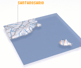 Places with similar names to Santa Rosario, Philippines ::
// Santa Rosario (PH)
// Santo Rosario (PH)
// Santo Rosario (PH)
// Santo Rosario (PH)
// Santo Rosario (PH)
// Santo Rosario (PH)
// Santo Rosario (PH)
// Santo Rosario (PH)
// Santo Rosario (PH)
// Santo Rosario (PH)
Disclaimer :: Information on this page comes without warranty of any kind |
||
|
Where is Santa Rosario? Elevation and coordinates ::
Latitude (lat): 9°57'54"N Longitude (lon): 124°15'43"E
Elevation (approx.): 201m (map arrows pan, magnifying glasses zoom) |
||
|
Visiting Santa Rosario? Hotel/Accommodation ::
Book a hotel in Santa Rosario Travel Guide ::
Buy a travel guide for Philippines rental cars ::
car rental offers GPS waypoint ::
download a GPX waypoint (PoI) of Santa Rosario for your GPS receiver
|
||