|
search place name
|
||
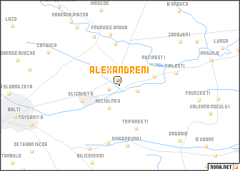
Alexăndreni (Raionul )) (( Anenii Noi, Moldova)Alexăndreni is a town in the Raionul )) (( Anenii Noi region of Moldova. An overview map of the region around Alexăndreni is displayed below.
regional and 3d topo map of Alexăndreni, Moldova ::
Alexăndreni airports ::
The nearest airport is IAS - Iasi, located 77.7 km south west of Alexăndreni.
Other airports nearby include KIV - Kichinau Fir/acc/com Chisinau Intl (117.0 km south east), SCV - Suceava Stefan Cel Mare (129.8 km west), BCM - Bacau (167.8 km south west), Nearby towns ::
Biruinţa (1.3km north west) //
Grigoreşti (1.3km south west) //
Heciul Vechi (2.0km south east) //
Heciul Nou (3.7km south) //
Ţipleteşti (3.8km east) //
Putineşti (4.9km north east) //
Elizaveta (4.6km south west) //
Mărăşeşti (6.5km north) //
Trifăneşti (7.0km south) //
Frumuşica Nouă (8.0km north) //
Cubolta (8.1km north) //
Ţipleşti (6.2km east) //
[all distances 'as the bird flies' and approximate]  Places with similar names to Alexăndreni, Moldova ::
// Aleksandrów Nowy (PL)
// Aleksandrinė (LT)
// Alexandrina (RO)
// Alexandrina (RO)
// Aleksandreni (UA)
// Aleksandrino (RU)
// Alexandrina (BR)
// Alexandrina (BR)
// Alexăndreni (MD)
Disclaimer :: Information on this page comes without warranty of any kind |
||
|
Where is Alexăndreni? Elevation and coordinates ::
Latitude (lat): 47°48'20"N Longitude (lon): 28°4'33"E
Elevation (approx.): 90m (map arrows pan, magnifying glasses zoom) |
||
|
Visiting Alexăndreni? Hotel/Accommodation ::
Book a hotel in Alexăndreni Travel Guide ::
Buy a travel guide for Moldova rental cars ::
car rental offers GPS waypoint ::
download a GPX waypoint (PoI) of Alexăndreni for your GPS receiver
|
||