|
search place name
|
||
María Luisa (Samaná, Dominican Republic)María Luisa is a town in the Samaná region of Dominican Republic. An overview map of the region around María Luisa is displayed below.
regional and 3d topo map of María Luisa, Dominican Republic ::

María Luisa airports ::
The nearest airport is SDQ - Santo Domingo Las Americas Intl, located 94.0 km south of María Luisa.
Other airports nearby include LRM - La Romana Casa De Campo Intl (95.7 km south east), PUJ - Punta Cana Intl (124.9 km south east), STI - Santiago Cibao Intl (135.2 km west), POP - Puerto Plata Gregorio Luperon Intl (143.0 km north west), Nearby towns ::
La Verita (0.0km north) //
La Aguada (1.8km east) //
Acosta (1.8km east) //
Santa Bárbara de Samaná (1.8km east) //
La Palmilla (1.8km east) //
La Bastilla (1.8km west) //
Romango (1.8km west) //
Noroeste (1.8km west) //
Río San Juan (2.5km north east) //
Anadel (2.5km south east) //
Los Grini (2.5km south west) //
La Cruz (3.7km north) //
La Esperanza (3.7km north) //
La Casualidad (3.7km north) //
Monte Rojo (3.5km east) //
Los Algarrobos (3.5km west) //
Callejón Javier (3.5km west) //
La Laguna (4.1km north east) //
Villa Clara (4.0km south east) //
Doncel (4.0km south west) //
Honduras (4.0km south west) //
Majagualito (5.3km west) //
Arenazos (5.3km west) //
La Majagua (5.8km north) //
Río Los Cocos (5.6km west) //
Los Gratinices (5.6km east) //
Carenero (5.6km east) //
Arroyo Grande (5.6km east) //
El Castaño (6.6km north west) //
[all distances 'as the bird flies' and approximate] 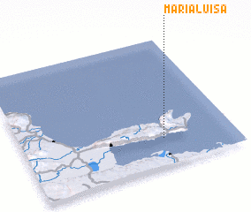 Places with similar names to María Luisa, Dominican Republic ::
// Morles (DE)
// Morlesau (DE)
// Maureles (PT)
// Meireles (PT)
// Merlães (PT)
// Mourelos (PT)
// Mourelos (PT)
// María Luisa (CU)
// María Luisa (CU)
// María Luisa (CU)
Disclaimer :: Information on this page comes without warranty of any kind |
||
|
Where is María Luisa? Elevation and coordinates ::
Latitude (lat): 19°13'0"N Longitude (lon): 69°20'0"W
Elevation (approx.): 94m (map arrows pan, magnifying glasses zoom) |
||
|
Visiting María Luisa? Hotel/Accommodation ::
Book a hotel in María Luisa Travel Guide ::
rental cars ::
car rental offers GPS waypoint ::
download a GPX waypoint (PoI) of María Luisa for your GPS receiver
|
||