|
search place name
|
||
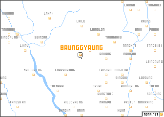
Baunggyaung (Chin, Myanmar)Baunggyaung is a town in the Chin region of Myanmar. An overview map of the region around Baunggyaung is displayed below.
regional and 3d topo map of Baunggyaung, Myanmar ::
Baunggyaung airports ::
The nearest airport is CXB - Cox's Bazar Coxs Bazar, located 108.1 km west of Baunggyaung.
Other airports nearby include AKY - Sittwe (124.2 km south), CGP - Chittagong Shah Amanat Intl (164.0 km north west), KYP - Kyaukpyu (209.9 km south), Nearby towns ::
Rat Ki (2.5km north east) //
Charadaung (5.1km south west) //
An Kang (5.2km east) //
Twi Shan (6.4km south east) //
Laing Lon (6.5km north east) //
Raik Don (6.5km north east) //
Laile (7.4km north) //
Praunglaung (7.6km south east) //
Taung Bwei (7.8km north east) //
Daswe (8.2km south east) //
Themawa (9.0km south west) //
[all distances 'as the bird flies' and approximate] 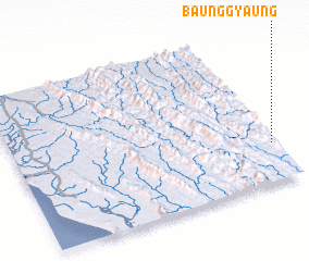 Places with similar names to Baunggyaung, Myanmar ::
// Ban Ko Yai Nak (TH)
// Ban Ko Yang (TH)
// Ban Ko Yang (TH)
// Bangayanga (CF)
// Bongoyankoi (CD)
// Ban Nakayong (LA)
// Baunggyaung (MM)
Disclaimer :: Information on this page comes without warranty of any kind |
||
|
Where is Baunggyaung? Elevation and coordinates ::
Latitude (lat): 21°15'0"N Longitude (lon): 92°59'0"E
Elevation (approx.): 224m (map arrows pan, magnifying glasses zoom) |
||
|
Visiting Baunggyaung? Hotel/Accommodation ::
Book a hotel in Baunggyaung Travel Guide ::
Buy a travel guide for Myanmar rental cars ::
car rental offers GPS waypoint ::
download a GPX waypoint (PoI) of Baunggyaung for your GPS receiver
|
||