|
search place name
|
||
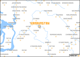
Kamaungtaw (Rakhine, Myanmar)Kamaungtaw is a town in the Rakhine region of Myanmar. An overview map of the region around Kamaungtaw is displayed below.
regional and 3d topo map of Kamaungtaw, Myanmar ::
Kamaungtaw airports ::
The nearest airport is KYP - Kyaukpyu, located 60.5 km south west of Kamaungtaw.
Other airports nearby include AKY - Sittwe (112.0 km west), SNW - Thandwe (159.4 km south), CXB - Cox's Bazar Coxs Bazar (268.6 km north west), Nearby towns ::
Thinchaung (1.7km east) //
Ye-ngan (2.5km south west) //
Letmauk (4.1km north west) //
Kolān (3.9km north west) //
Kutwa (5.2km west) //
Sakawbyet (5.2km west) //
Thēchaung (7.4km north) //
Kyetwe (7.2km west) //
Thēchaung (8.2km north east) //
Shaukchôn (7.9km north west) //
Nepasaichaung (7.9km south east) //
Kyaukchaung (7.9km south west) //
Sabagyi (8.2km south east) //
Yaingkauk (8.9km north east) //
Nigyaw (10.2km north west) //
[all distances 'as the bird flies' and approximate]  Places with similar names to Kamaungtaw, Myanmar ::
// Cambinocod (PH)
// Cambinocot (PH)
// Kambinokot (PH)
// Kamień Kotowy (PL)
// Comingtee (US)
// Caminguato (MX)
// Gammanagoda (LK)
// Komangoda (LK)
// Komana Kouta (ML)
// Camingodo (MZ)
Disclaimer :: Information on this page comes without warranty of any kind |
||
|
Where is Kamaungtaw? Elevation and coordinates ::
Latitude (lat): 19°51'0"N Longitude (lon): 93°54'0"E
Elevation (approx.): 42m (map arrows pan, magnifying glasses zoom) |
||
|
Visiting Kamaungtaw? Hotel/Accommodation ::
Book a hotel in Kamaungtaw Travel Guide ::
Buy a travel guide for Myanmar rental cars ::
car rental offers GPS waypoint ::
download a GPX waypoint (PoI) of Kamaungtaw for your GPS receiver
|
||