|
search place name
|
||
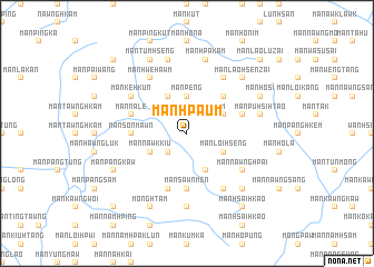
Mān Hpa-ūm (Shan, Myanmar)Mān Hpa-ūm is a town in the Shan region of Myanmar. An overview map of the region around Mān Hpa-ūm is displayed below.
regional and 3d topo map of Mān Hpa-ūm, Myanmar ::
Mān Hpa-ūm airports ::
The nearest airport is LSH - Lashio, located 99.7 km south west of Mān Hpa-ūm.
Other airports nearby include MYT - Myitkyina (219.4 km north west), Nearby towns ::
Mān Tōn-lōm (2.5km north east) //
Mān Ho-hkang (2.5km south west) //
Möng Si (2.5km north west) //
Mān Peng (3.7km north) //
Mān Ho-et (4.1km south east) //
Mān Loi Hseng (3.9km south east) //
Mān Pinghkūm (3.9km north east) //
Mān Kūnghsa (4.1km north west) //
Mān Nawkkiu (3.9km south west) //
Mān Panglōmnō (5.0km north east) //
Mān Sawnmen (5.6km south) //
Mān Sonmawn (5.1km west) //
Mān Pung (5.1km west) //
Mān Mau (5.8km south) //
Mān Kawng-hka (5.4km east) //
Mān Na-le (5.4km west) //
Mān Lomhkawng (6.5km south east) //
Mān Nawnghpai (6.3km south east) //
Mān Ho-hsa (6.5km north east) //
Mān Kēnghkōngkang (6.5km north west) //
Mān Hwe-hawm (6.5km north west) //
Mān Ke-hkūn (6.3km north west) //
Mān Panghsak (7.4km south) //
Mān Pū-hsi-htao (7.0km east) //
Mān Hpa-kām (7.6km north) //
Mān Sūt (7.6km north) //
Mān Nawng (7.5km south east) //
Mān Lao-hsenzai (7.5km north east) //
Mān Pangkaw (7.7km south west) //
[all distances 'as the bird flies' and approximate]  Places with similar names to Mān Hpa-ūm, Myanmar ::
// Monopamba (CO)
// Munie-Pembe (CD)
Disclaimer :: Information on this page comes without warranty of any kind |
||
|
Where is Mān Hpa-ūm? Elevation and coordinates ::
Latitude (lat): 23°39'0"N Longitude (lon): 98°24'0"E
Elevation (approx.): 1034m (map arrows pan, magnifying glasses zoom) |
||
|
Visiting Mān Hpa-ūm? Hotel/Accommodation ::
Book a hotel in Mān Hpa-ūm Travel Guide ::
Buy a travel guide for Myanmar rental cars ::
car rental offers GPS waypoint ::
download a GPX waypoint (PoI) of Mān Hpa-ūm for your GPS receiver
|
||