|
search place name
|
||
Ngeo-kunhtang (Shan, Myanmar)Ngeo-kunhtang is a town in the Shan region of Myanmar. An overview map of the region around Ngeo-kunhtang is displayed below.
regional and 3d topo map of Ngeo-kunhtang, Myanmar ::

Ngeo-kunhtang airports ::
The nearest airport is LSH - Lashio, located 148.5 km south west of Ngeo-kunhtang.
Other airports nearby include MYT - Myitkyina (210.2 km north west), Nearby towns ::
Pai-yüho (2.5km north west) //
Yehwangpo (3.9km south west) //
Tao-yaw (4.1km north east) //
Hsi-choling (5.1km west) //
Si-htonghping (5.4km west) //
Mifung Chai (5.4km west) //
Chatzushu (8.1km north west) //
Chalu Chai (7.7km north west) //
Shitouzhai (8.2km south east) //
Laolongko (9.0km north west) //
Shaotishan (9.0km north east) //
Tawantzu (10.0km north west) //
Nyu-chang (10.0km south west) //
[all distances 'as the bird flies' and approximate] 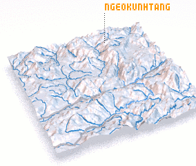 Places with similar names to Ngeo-kunhtang, Myanmar :: Disclaimer :: Information on this page comes without warranty of any kind |
||
|
Where is Ngeo-kunhtang? Elevation and coordinates ::
Latitude (lat): 23°58'0"N Longitude (lon): 98°44'0"E
Elevation (approx.): 1724m (map arrows pan, magnifying glasses zoom) |
||
|
Visiting Ngeo-kunhtang? Hotel/Accommodation ::
Book a hotel in Ngeo-kunhtang Travel Guide ::
Buy a travel guide for Myanmar rental cars ::
car rental offers GPS waypoint ::
download a GPX waypoint (PoI) of Ngeo-kunhtang for your GPS receiver
|
||