|
search place name
|
||
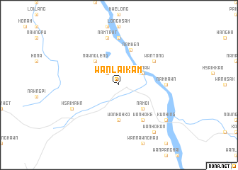
Wān Lai-kam (Shan, Myanmar)Wān Lai-kam is a town in the Shan region of Myanmar. An overview map of the region around Wān Lai-kam is displayed below.
regional and 3d topo map of Wān Lai-kam, Myanmar ::
Wān Lai-kam airports ::
The nearest airport is MOG - Mong Hsat, located 130.7 km south east of Wān Lai-kam.
Other airports nearby include KET - Kengtung (131.8 km east), HEH - Heho (176.8 km west), THL - Tachilek Tachileik (189.3 km south east), LSH - Lashio (191.1 km north), Nearby towns ::
Wān Hsan (2.5km north west) //
Kon-aw (3.9km north east) //
Nam-oi (5.1km south east) //
Nawngleng (5.1km north west) //
Wān Ho-hkö (5.6km south) //
Namwen (5.8km north) //
Wān Tong (6.4km north east) //
Wān Ho-ke (6.5km south east) //
Nammawn (6.9km east) //
Namtawng (7.4km north) //
Namtawt (7.6km north) //
Hsai-mawn (7.8km south west) //
Kunhing (8.9km south east) //
Wān Kontawng (8.9km south east) //
Wān Ho-kon (9.0km south east) //
[all distances 'as the bird flies' and approximate] 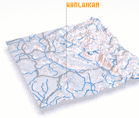 Places with similar names to Wān Lai-kam, Myanmar ::
Disclaimer :: Information on this page comes without warranty of any kind |
||
|
Where is Wān Lai-kam? Elevation and coordinates ::
Latitude (lat): 21°21'0"N Longitude (lon): 98°22'0"E
Elevation (approx.): 558m (map arrows pan, magnifying glasses zoom) |
||
|
Visiting Wān Lai-kam? Hotel/Accommodation ::
Book a hotel in Wān Lai-kam Travel Guide ::
Buy a travel guide for Myanmar rental cars ::
car rental offers GPS waypoint ::
download a GPX waypoint (PoI) of Wān Lai-kam for your GPS receiver
|
||