|
search place name
|
||
Wan Pa-mawng (Shan, Myanmar)Wan Pa-mawng is a town in the Shan region of Myanmar. An overview map of the region around Wan Pa-mawng is displayed below.
regional and 3d topo map of Wan Pa-mawng, Myanmar ::

Wan Pa-mawng airports ::
The nearest airport is LSH - Lashio, located 129.3 km north of Wan Pa-mawng.
Other airports nearby include HEH - Heho (137.6 km south west), MDL - Mandalay Intl (144.8 km west), MOG - Mong Hsat (246.7 km south east), Nearby towns ::
Wān Kenghkam (0.0km north) //
Wan Na-hi (1.7km west) //
Wān Hpa-hkau (3.7km north) //
Wān Na-ong (4.1km north west) //
Wān Kongpau (4.1km north west) //
Wān Pahka (4.1km south west) //
Wan Longyon (5.6km north) //
Wan Nawngmo (5.6km north) //
Wān Pa-hkaw (5.5km east) //
Wān Nā-ping (5.8km north) //
Wān Pongyawng (6.4km south east) //
Wan Nawngya-hsai (6.4km south east) //
Wān Kat (7.4km north) //
Wān Kengtawng (7.6km south) //
Wan Namhkon (8.2km south east) //
Wān Pangpaw-ye (8.8km south east) //
[all distances 'as the bird flies' and approximate] 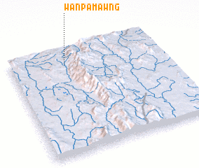 Places with similar names to Wan Pa-mawng, Myanmar ::
// Wān Pawmöng (MM)
// Wān Pu-möng (MM)
// Wān Pawmong (MM)
// Wān Pawmöng (MM)
// Wān Pawmöng (MM)
// Wān Pawmöng (MM)
// Wān Pa-mong (MM)
// Wān Pawmöng (MM)
// Wān Pawmüng (MM)
// Wān Pu-meng (MM)
Disclaimer :: Information on this page comes without warranty of any kind |
||
|
Where is Wan Pa-mawng? Elevation and coordinates ::
Latitude (lat): 21°52'0"N Longitude (lon): 97°22'0"E
Elevation (approx.): 825m (map arrows pan, magnifying glasses zoom) |
||
|
Visiting Wan Pa-mawng? Hotel/Accommodation ::
Book a hotel in Wan Pa-mawng Travel Guide ::
Buy a travel guide for Myanmar rental cars ::
car rental offers GPS waypoint ::
download a GPX waypoint (PoI) of Wan Pa-mawng for your GPS receiver
|
||